Maroussi. The evolution of its social and demographic profile in recent decades
Maloutas Thomas
Quartiers, Social Structure
2022 | Mar
Integration into the urban fabric
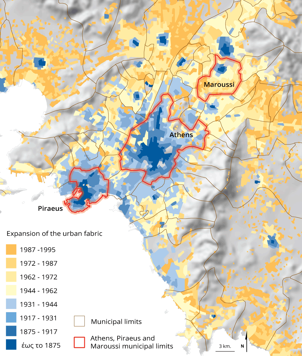
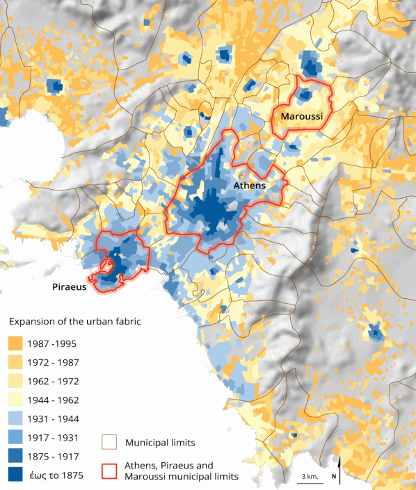
Maroussi is a settlement of Attica with a history that begins from the ancient Athmonon (Μουρουγκλού 2010). From the last quarter of the 19th century until the 2nd World War, Maroussi was an independent urban settlement in the northern part of the Attica basin, as shown in map 1 [1]. According to the same map, Maroussi was gradually integrated into the urban fabric of the city, especially from the 1970s onwards.
Map 1: The gradual expansion of the urban fabric in Attica and the integration of Maroussi
Source: Αβδελίδη (2000: 30)
The rapid rise in the level of education of the inhabitants of Maroussi
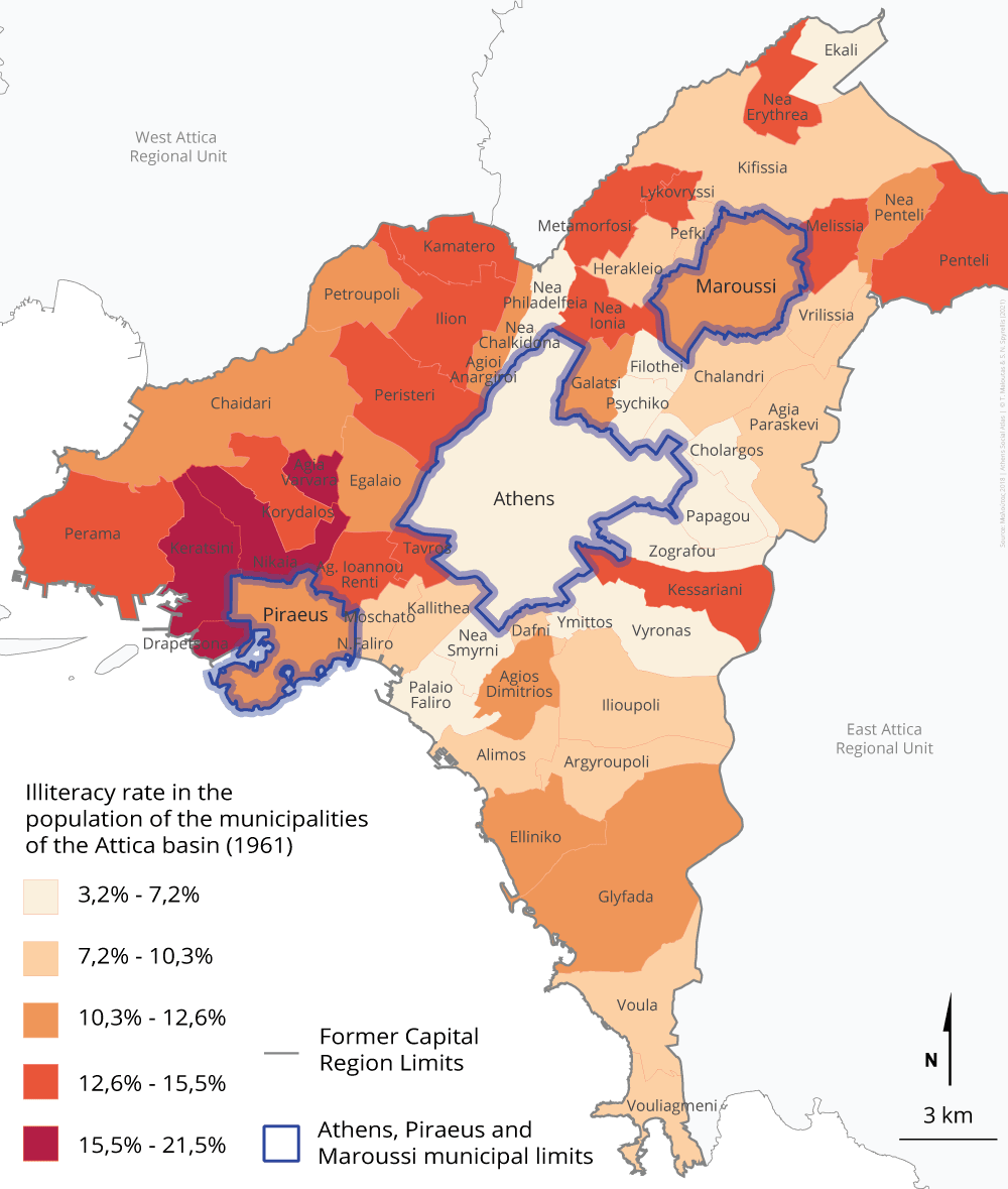
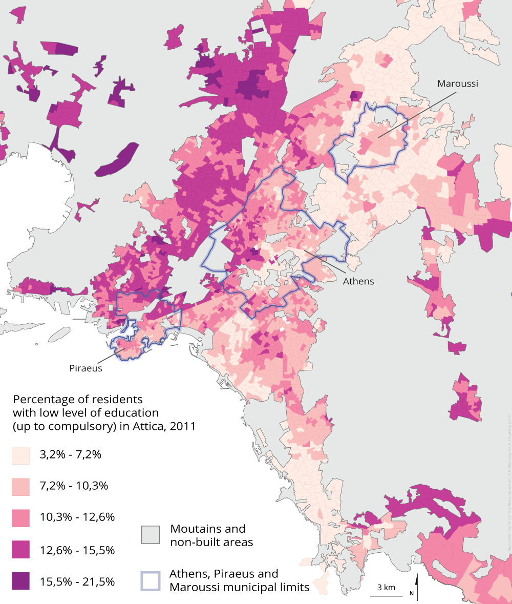
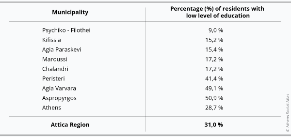
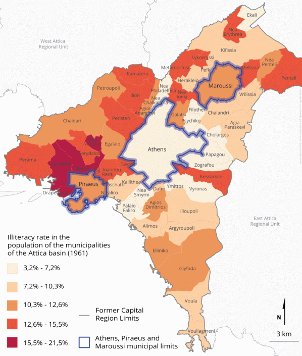
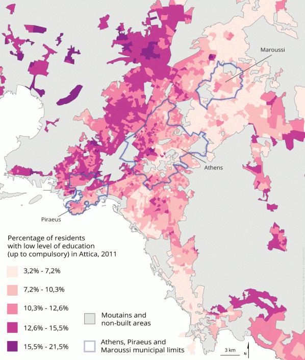
The evolution of the social profile of Maroussi followed the general course of the upward social mobility, which characterized the whole city and which showed a special dynamism during the post-war period. The upward trend for the population in Maroussi, however, seems to have been more intense than that of the city as a whole, as shown by its comparative position in maps 2 and 3. In map 2, where the municipalities of the Attica basin are presented according to percentage of their illiterate inhabitants in 1961, Maroussi is in the intermediate category, between the center and its surrounding areas with the most educated inhabitants and in the periphery — especially the western part — where the illiteracy rate was the highest. This picture changes completely in 2011 according to map 3 and table 1, where the municipalities of Attica are presented according to the percentage of their adult residents with a low level of education (up to nine years [compulsory education]). Maroussi in 2011 was among the areas with the lowest concentration of residents with a low level of education.
Map 2: Illiteracy rate in the population of the municipalities of the Attica basin, 1961
Source: Μαλούτας (2018: 103)
Map 3: Percentage of residents with low level of education (up to compulsory) in Attica, 2011
Data source: EKKE-ELSTAT (2015)
Table 1: Percentage of residents with low level of education (up to compulsory) in a selected group of municipalities of Attica, 2011
Data source: EKKE-ELSTAT (2015)
The evolution of the age profile of Maroussi
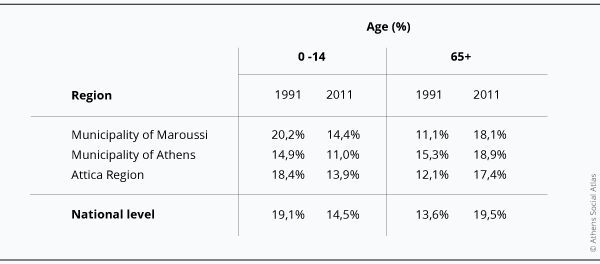
The age structure in the whole Attica Region, but also in the whole country, changed significantly in the period 1991 – 2011. A key element of this change was the decrease in the percentage of children (0 to 14 years) and the increase in the elderly (65 years and above). In Maroussi, in relation to the whole Attica Region, the percentage of children decreased and approached that of the Region and, at the same time, the percentage of the elderly, which was lower, exceeded the average of the Region (Table 2).
Table 2: Percentage of children (0-14 years) and elderly (65 years and over) in the total population, 1991 and 2011
Data source: EKKE-ELSTAT (2015)
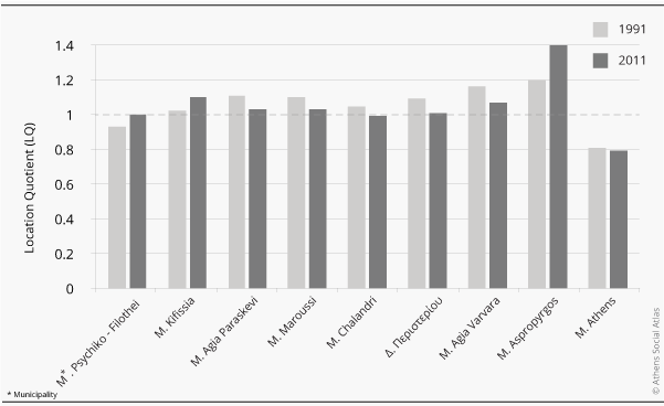
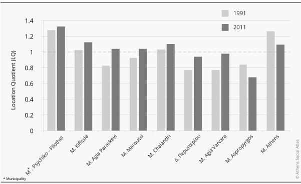
The following two figures (1 and 2) present the evolution of the age of some indicative municipalities of the Attica Region, in relation to the whole Region. These figures indicate the location quotient (LQ), which is the fraction of the percentage of the reference age category in each municipality divided by the corresponding fraction in the whole Region. Thus, for example, an LQ with a value of 1.2 for 0-14 years in municipality X means that in municipality X the percentage of 0-14 years is 1.2 times higher than the percentage of this category in the whole Region. Figure 1 shows that in the period 1991-2011 in the Municipality of Maroussi — as in other neighboring municipalities, but also in some municipalities on the western side of the city — the percentage of children decreased and approached the average of the Attica Region. On the contrary, the percentage of children increased in municipalities that are positioned at the edges of the class hierarchy based on their inhabitants’ occupational profiles (Filothei-Psychiko and Kifissia on the one hand and Aspropyrgos on the other). Figure 2 shows that aging is a general feature of most municipalities in the Region, except the Municipality of Athens — due to the significant influx of young immigrants and the outflow of middle-aged and elderly native Greeks — and some municipalities with special characteristics, such as Aspropyrgos.
Figure 1: Location coefficient (LQ) for the age category 0-14 years in a selected group of municipalities of Attica, 1991 and 2011
Data source: EKKE-ELSTAT (2015)
Figure 2: Location coefficient (LQ) for the age category 65 years and over in a selected group of municipalities of Attica, 1991 and 2011
Data source: EKKE-ELSTAT (2015)
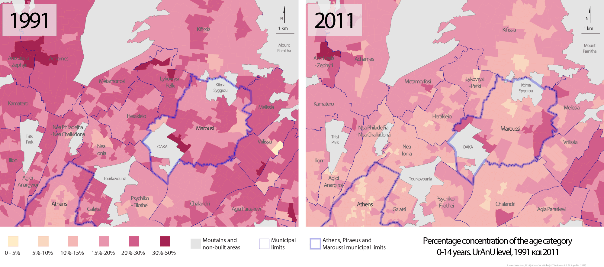
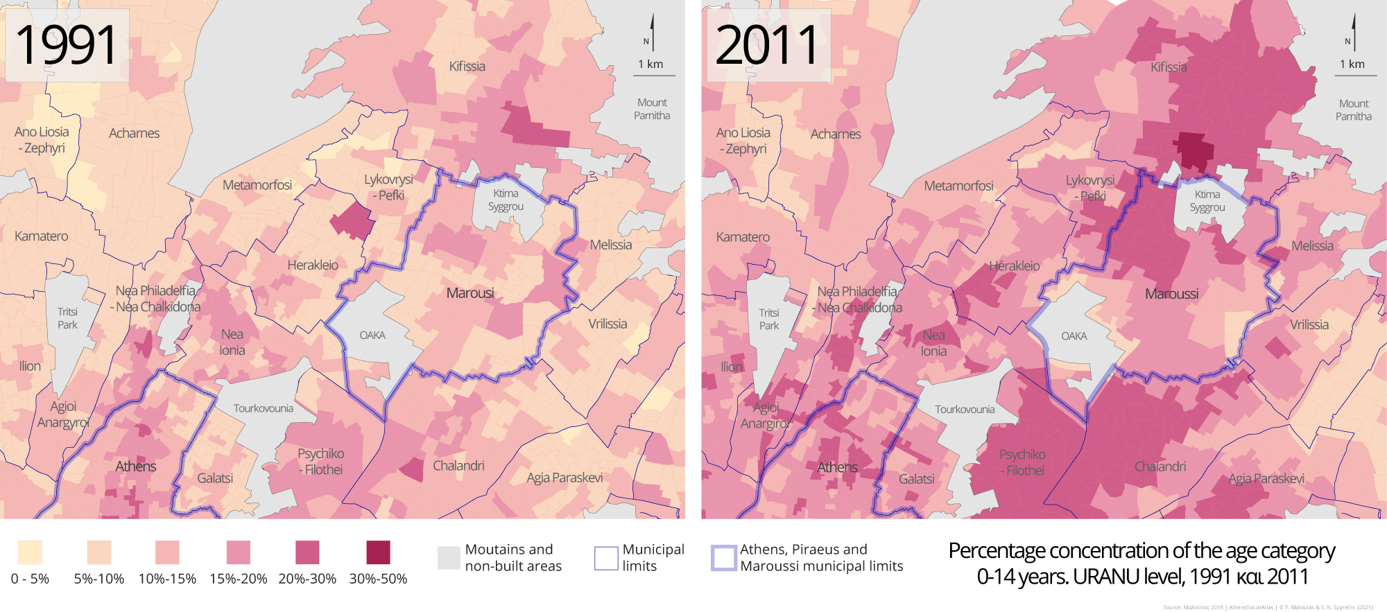
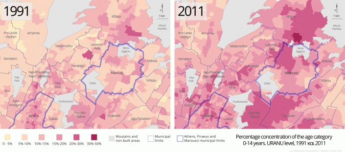
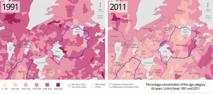
The age physiognomy of an area does not necessarily reflect what happens throughout the whole area. In Maroussi, the younger ages (0-14 years) are concentrated mainly in the newly built areas in the southern part of the municipality and secondarily on the east side (towards Melissia and Vrilissia), while the elderly show a clear concentration in the traditional core on the north side of the settlement, close to the border with Kifissia and Pefki (Maps 4-5 and 6-7).
Maps 4-5: Percentage concentration of the age category 0-14 years within the Municipality of Maroussi per URANU [2], 1991 και 2011
Maps 6-7: Percentage concentration of the age category 65 years and over within the Municipality of Maroussi per URANU, 1991 and 2011
Data source: EKKE-ELSTAT (2015)
The evolution of Maroussi’s social profile
As evidenced by the evolution of the level of education of the inhabitants between 1961 and 2011, mentioned at the beginning of this text, Maroussi shifted from the middle of the social hierarchy of the municipalities of Attica, where it was placed in 1961, to the highest positions in 1991 and , even more so, in 2011. This shift becomes clearer if we look at the changes in the socio-occupational physiognomy of its inhabitants.
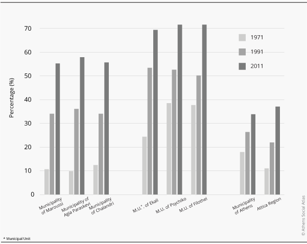
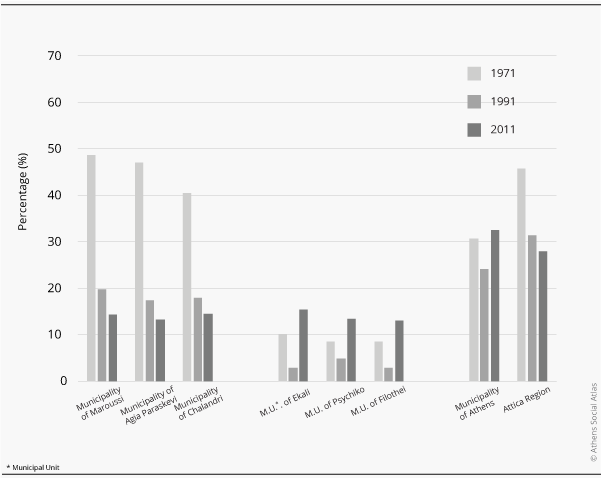
If we focus on the broad extreme socio-occupational categories — professionals (such as doctors, lawyers, engineers) and managers, on the one hand, and workers, on the other — we know that in recent decades there has been a significant expansion of the upper social and professional pole in Athens and a shrinkage of the lower (Μαλούτας 2018: 80). Maroussi is one of the areas of the city where these changes were particularly intense, both in terms of the enlargement of the upper pole and the shrinkage of the lower one (Figures 3 and 4).
Figure 3: Percentage of professionals and managers in the active population in a selected group of municipalities of Attica, 1971, 1991 and 2011
Data source: ΕΚΚΕ-ΕΛΣΤΑΤ (2015)
Figure 4: Percentage of workers in the active population in a selected group of municipalities of Attica, 1971, 1991 and 2011
Data source: ΕΚΚΕ-ΕΛΣΤΑΤ (2015)
The changes between 1971 and 2011 were particularly important. Professionals and managers in the entire Attica Region more than tripled (from 11% to 37%). For Maroussi, however, this increase was much larger: from 10.6% to 55.4%. Neighboring municipalities with a similar social physiognomy, such as Agia Paraskevi and Chalandri, had a similar course. Municipalities where these categories traditionally had the highest rates — such as Psychiko and Filothei — reached even higher rates in 2011 (about 70%) but had started with high rates as early as 1971 (about 35%). Therefore, during this period there is a convergence of Maroussi with the traditional poles of concentration of the higher social and professional categories.
In terms of workers, Maroussi — and other neighboring municipalities with similar social character and development — lost about 4/5 of their share between 1971 and 2011 (from 49% to 14.4%). The convergence with the traditional suburbs of the upper social strata, in terms of this occupational pole, is even greater than for the upper pole, as in 2011 the percentage of workers is almost identical (about 15%). This convergence is a result of the great decrease of the percentage of workers in Maroussi (and in the neighboring municipalities with a similar physiognomy) and, at the same time, of its increase in the suburbs of the traditional concentration of the upper socio-occupational categories between 1971 and 2011. In the first case it is about the rapid increase of the percentage of middle and upper-middle classes in socially mixed suburban areas. In the second case, the exclusive class character of the strongholds of high social categories is maintained since the increase of workers is mainly due to increased presence of unskilled staff — often migrants — employed in domestic help services.
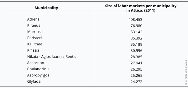
Maroussi’s rise in the social hierarchy of the residential areas of the Athenian metropolis was not only a result of his attractiveness as a residential area for the upper-middle social strata, but also of his role as a place of work. The linear expansion of the Athenian center affected the municipalities located on major roads, such as Kifissias and Syggrou avenues. Maroussi was probably influenced more than all the involved municipalities, both quantitatively and qualitatively. Quantitatively because in 2011 it had become the municipality with the third largest labor market in Attica, after the Municipalities of Athens and Piraeus (Table 3).
Table 3: Size of labor markets per municipality in Attica, 2011 (the first 11 are mentioned)
Data source: ΕΚΚΕ-ΕΛΣΤΑΤ (2015)
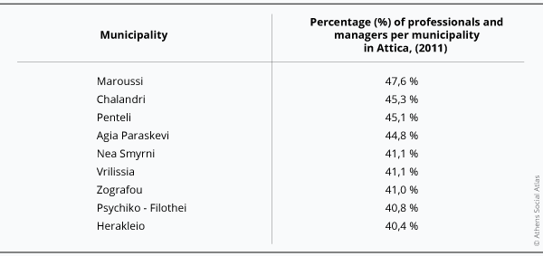
In terms of the quality dimension, the labor market in Maroussi is now a place of employment of the highest jobs in the Attica Region, surrounded by a wider circle of neighboring municipalities to which this labor market extends. Table 4 lists the labor markets of Attica with the highest percentage in high socio-occupational categories (professionals and managers). In this table, Maroussi occupies the first place, followed by five neighboring municipalities (Chalandri, Penteli, Agia Paraskevi, Vrilissia and Filothei-Psychiko) where there is now a wider labor market with similar characteristics, for which Maroussi is the center.
Table 4: Percentage of professionals and managers per municipality in Attica, 2011 (the first 9 are mentioned)
Data source: ΕΚΚΕ-ΕΛΣΤΑΤ (2015)
Another quality feature of the labor market in Maroussi is the very low percentage of workers (30.6%), which is the lowest among all municipalities in the Attica Region.
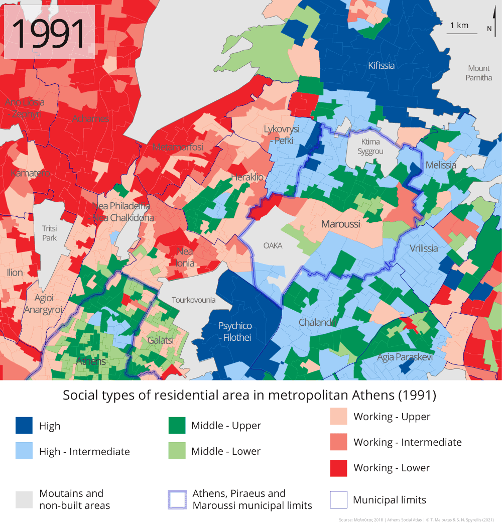
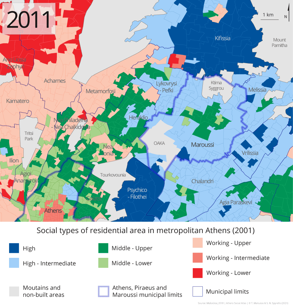
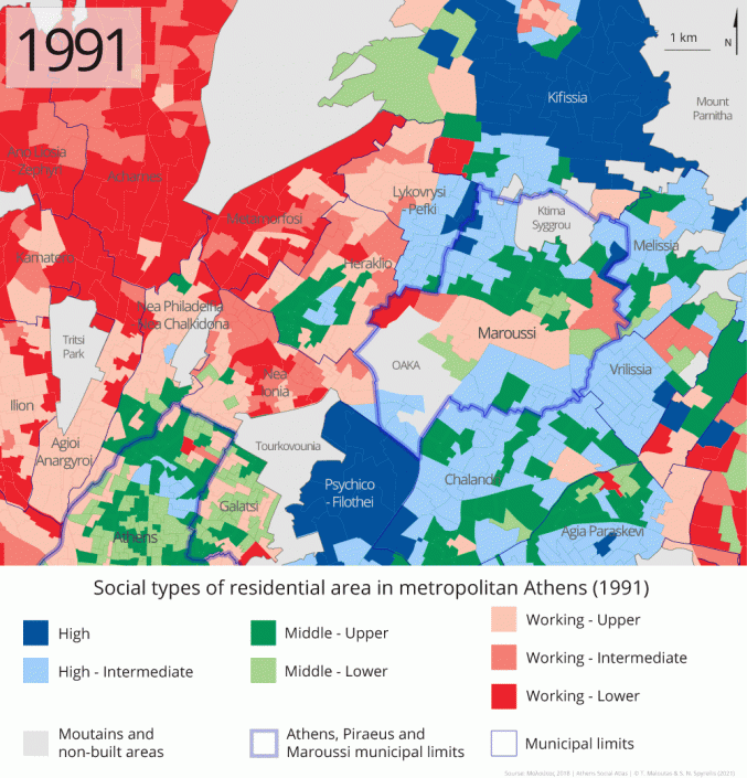
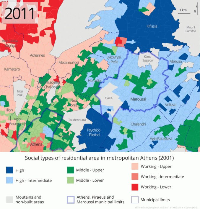
The evolution of the social profile of Marousi that is briefly described above, is reflected in maps 9 and 10, which present the social typology of residential areas in Attica founded on the socio-occupational composition of their inhabitants (Maloutas 2018, 120-121). During the twenty years 1991-2011, Maroussi and the surrounding areas experience the ‘domination’ of the middle and, mainly, the upper-middle classes, reflected by their over-representation among their inhabitants. In Maroussi, the few areas where the working classes were overrepresented lost their social profile, while a similar development is observed in neighboring and nearby municipalities in the west (Pefki, Heraklion and Lykovrysi).
Map 8: Social types of residential area in metropolitan Athens, URANUs, 1991
Source: Μαλούτας (2018: 121)
Map 9: Social types of residential area in metropolitan Athens, URANUs, 2011
Source: Μαλούτας (2018: 120)
In conclusion, in recent decades Maroussi has changed both in terms of age structure and social profile. In terms of age structure, Maroussi followed the general course of the Attica Region with the decrease of the percentage of children (0-14 years) and the increase of the percentage of the elderly (65 years and over). This course, however, was followed at a faster pace for both of these age groups. The change in the social profile of the municipality was particularly pronounced during the same period. Maroussi moved up many places in the social hierarchy of the residential areas of Attica and significantly approached the upper end of the hierarchy with the traditional suburbs of over-concentration of the highest social-professional categories. This development for Maroussi is due to three main reasons: (1) The inflows from the significant movement of middle and upper-middle classes from the center to the suburbs since the late 1970s. (2) The fact that it was a relatively sparsely populated area (along with important parts of the municipalities on its east and west side) where the relatively saturated and very expensive areas of traditional concentration of the high social strata –with which it is adjacent directly to the south (Filothei-Psychiko) and to the north (Kifissia)– could expand. (3) The rapid development of the local labor market and the social profile of the jobs it offers, which enhanced the attractiveness of Maroussi as a place of residence for the highly qualified and highly paid workforce employed in the wider region.
[1] This map was made by Kallistheni Avdelidi (2000) and depicts the gradual expansion of the urban fabric in Attica based on printed maps of the built-up area of Attica at various times from 1875 to 1995.
[2] Urban Analysis Unit (URANU). It is a spatial unit / division of the urban tissue of large Greek cities based on the Census Tracts of ELSTAT. URANUs have an average population of 1,200 people.
Αναφορά λήμματος
Maloutas, T. (2022) Maroussi. The evolution of its social and demographic profile in recent decades, in Maloutas T., Spyrellis S. (eds) Athens Social Atlas. Digital compendium of texts and visual material. URL: https://www.athenssocialatlas.gr/en/article/maroussi/ , DOI: 10.17902/20971.106
Αναφορά Άτλαντα
Μαλούτας Θ., Σπυρέλλης Σ. (επιμ.) (2015) Κοινωνικός άτλαντας της Αθήνας. Ηλεκτρονική συλλογή κειμένων και εποπτικού υλικού. URL: https://www.athenssocialatlas.gr/ , DOI: 10.17902/20971.9
References
- Αβδελίδη, Καλλισθένη (2000) Οι διαδοχικές επεκτάσεις του ιστού της Αθήνας, στο Μαλούτας Θ (επιμ.) Κοινωνικός και Οικονομικός Άτλας της Ελλάδας: Οι Πόλεις, Αθήνα – Βόλος: ΕΚΚΕ – Πανεπιστημιακές Εκδόσεις Θεσσαλίας, σ. 30-31.
- ΕΚΚΕ-ΕΛΣΤΑΤ (2015) Πανόραμα Απογραφικών Δεδομένων 1991-2011. Διαδικτυακή εφαρμογή πρόσβασης και επεξεργασίας απογραφικών δεδομένων (https://panorama.statistics.gr/).
- Μαλούτας, Θωμάς (2018) Η Κοινωνική Γεωγραφία της Αθήνας. Κοινωνικές ομάδες και δομημένο περιβάλλον σε μια νοτιοευρωπαϊκή μητρόπολη, Αθήνα: Αλεξάνδρεια.Μουρουγκλού, Άννα (2010) Αμαρούσιον. Όψεις της ιστορίας, της πόλης και του δήμου. Μαρούσι: Αλέξανδρος Ε.Π.Ε.
