The evolution of land uses and population in Psyrri district
Marougkas Konstantinos
Economy, Quartiers, Social Structure
2020 | Aug
The Psyrri district is one of the oldest districts of Athens. It is bounded by the streets of Evripidou, Athinas, Ermou, Agion Asomaton, Pireos (PanagiTsaldari) and, despite its limited surface, has changed in recent years, to reflect typical transformations that exist in the wider center of Athens (Καιροφύλας 2000).
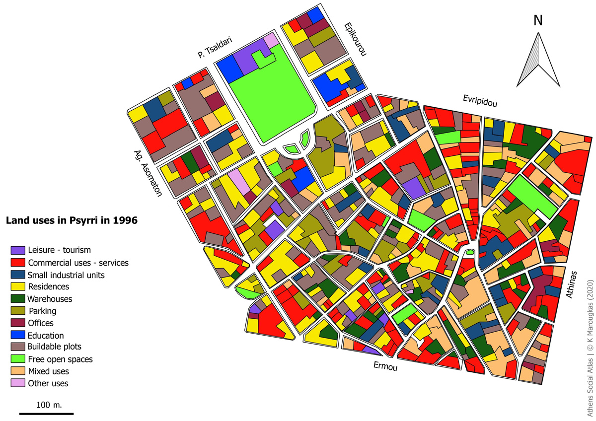
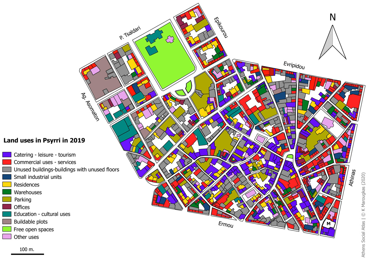
In this text, we track the spatial and social transformations which took place in the Psyrri district via a comparison of land use maps drawn in 1996 and 2019. The land uses maps of 1996 are based on a study by Attiko Metro while the corresponding maps of 2019, are based on fieldwork by the author. During the fieldwork, the uses of ground floors, upper floors, as well as the buildable open spaces were mapped separately, to give a complete picture of the area’s land uses.
The basemap for 1996, was designed with QGIS software, exactly as it was depicted in the map of Attiko Metro.
At the same time, the cartographic background for the 2019 map, was provided by ELSTAT and was edited using QGIS software to show the ground floor and upper floor uses, separately. In particular, the outlines of the buildings were redesigned and their ground floors and upper floors were labelled. The ELSTAT basemap was drawn in 2001[1], so, in some cases, the building boundary lines had to be redrawn in order to bring the map up to date.
From the first visit to the neighborhood of Psyrri, it became clear, that the area’s land use profile has changed significantly. Comparing the area’s land use maps of 1996 and 2019, one observes the changes that have occurred over a period of 23 years. These changes have significantly altered the district’s character
Psyrri land uses in 1996 and 2019
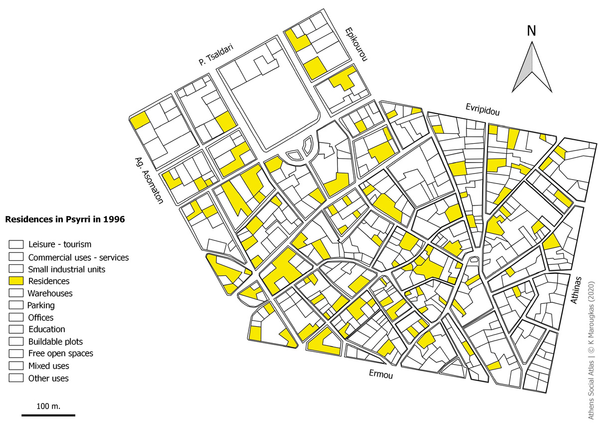
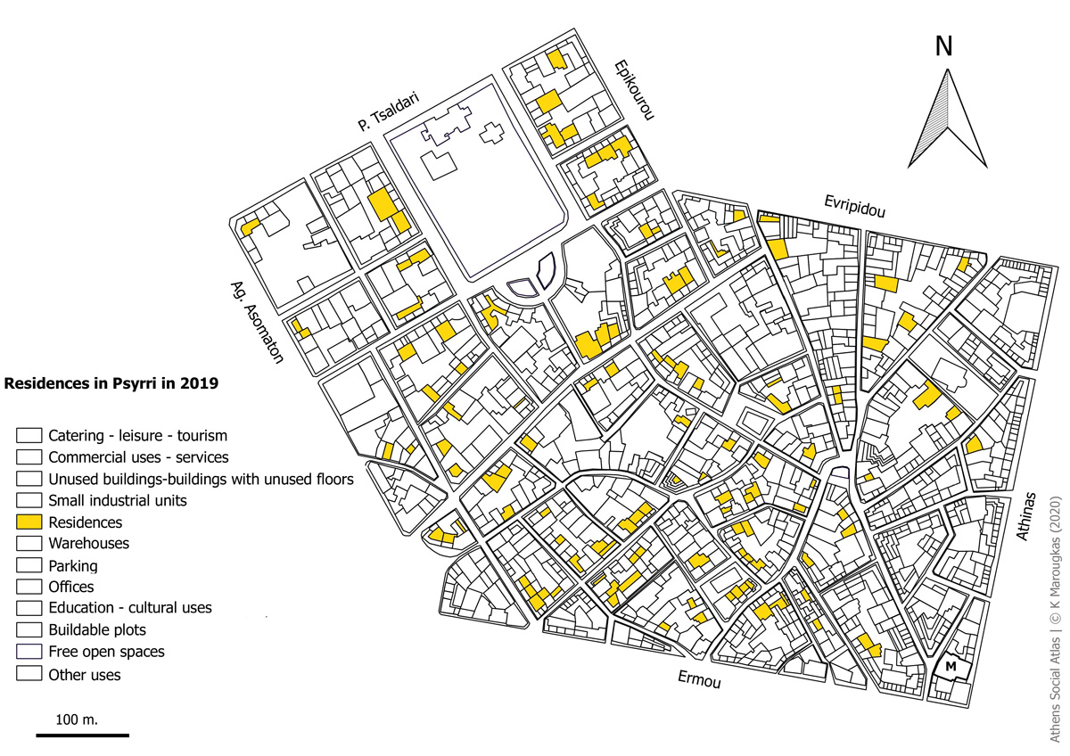
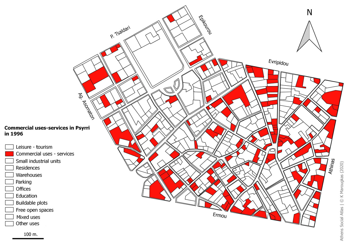
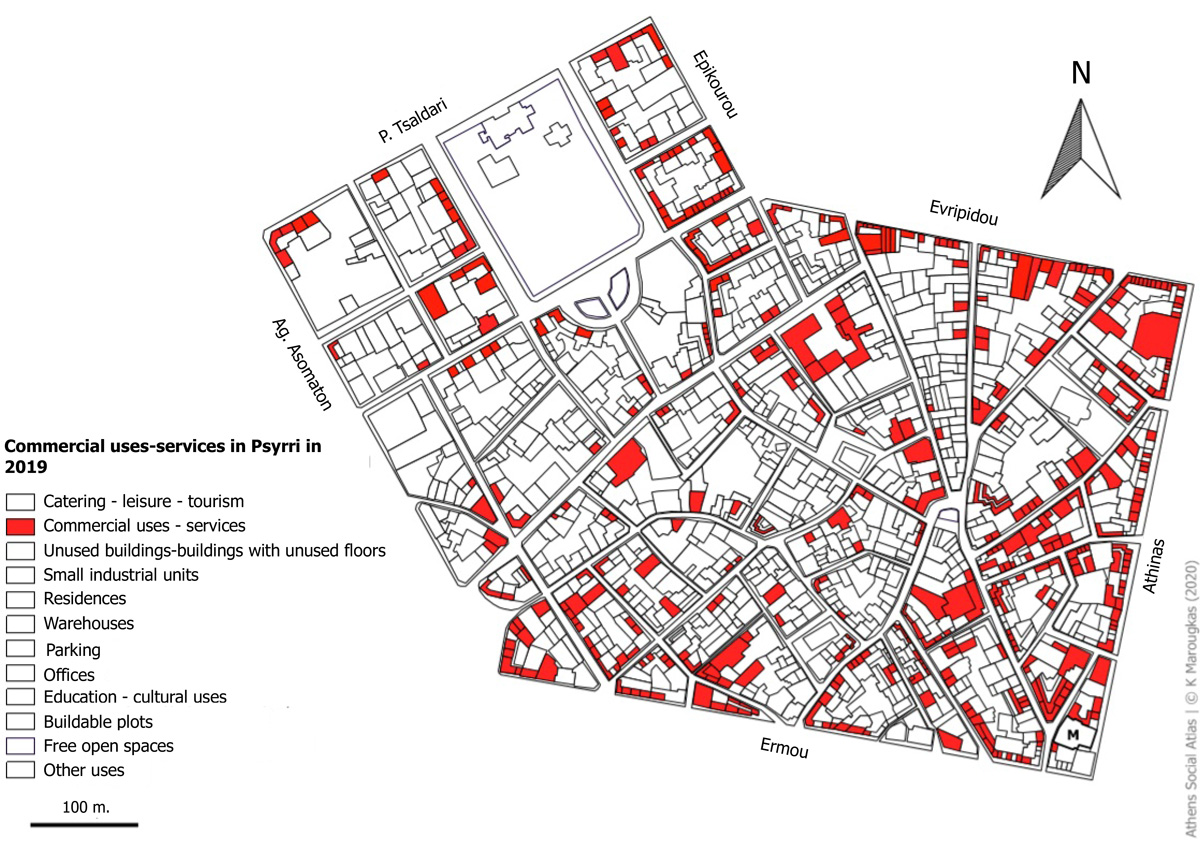
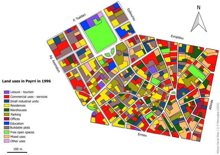
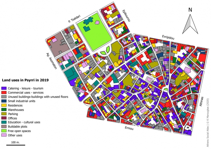
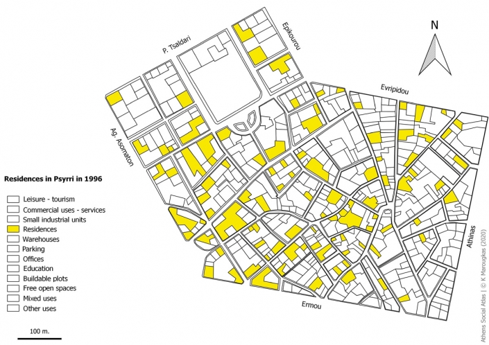
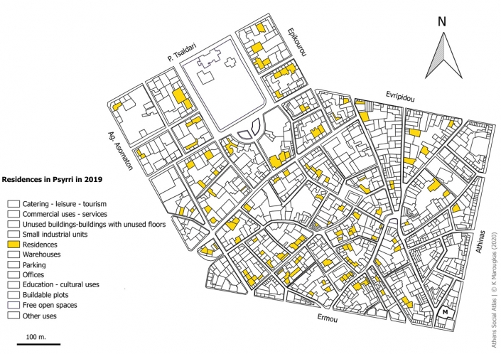
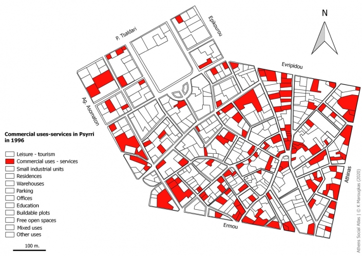
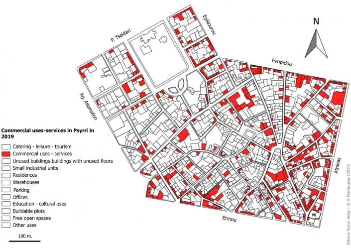
At first glance, it appears that in 1996, the area of Psyrri (Map 1) mainly hosted commercial uses and services , as well as residences. There was a large number of unbuilt plots. Map 2, which captures land uses in the district in 2019, shows that trade and services still maintain their momentum, as well as residences, which continue to be an important land use category. Catering, leisure services and tourism are nowadays among the region’s dominant and developing land uses.
Map 1: Land uses in Psyrri in 1996
Sources: ELSTAT basemap, Αttiko Μetro 1996 data, author’s analysis
Map 2: Land uses in Psyrri in 2019
Source:ELSTAT basemap, author’s data and analysis
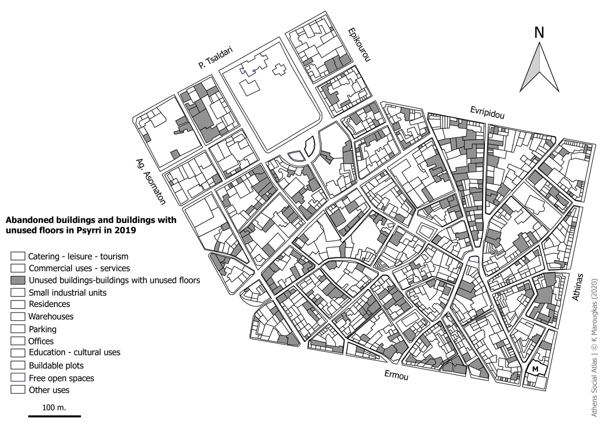
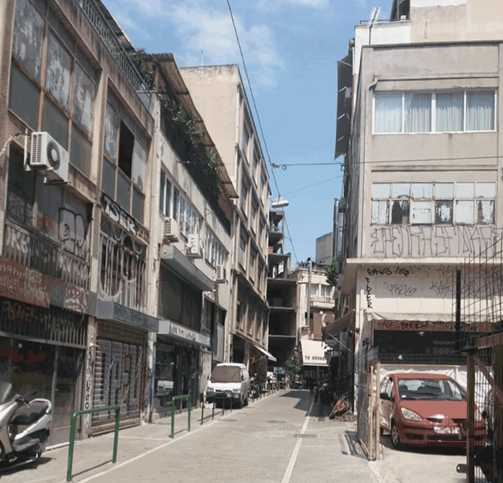
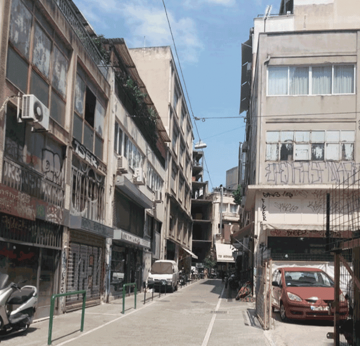
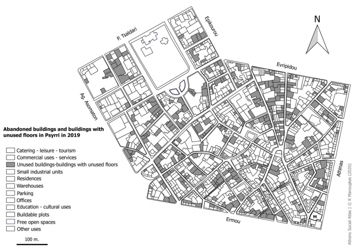
Finally, a large number of buildings are left unused. As shown in Map 3, these are either buildings that are entirely abandoned or buildings with some abandoned floors. We can find them everywhere in the district while some streets, such as Eschilou and Aristofanous are lined up with unused buildings. These streets, as shown in picture 1 (Aristofanous Street), show signs of abandonment and degradation where homeless people and drug addicts frequent.
Map 3: Abandoned buildings and buildings with unused floors in Psyrri in 2019
Source: ELSTAT basemap, author’s data and analysis
Photo 1: Unused buildings in Aristofanous Street
Source: Author 2019
The mapping of land uses in Psyrri, reveals that abandonement follows a pattern. That is to say, abandoned buildings cluster together in the same manner that commercial shopscreate some form of cluster too (Athens Traders Association 2017/ Εμπορικός Σύλλογος Αθηνών 2017)
Comparison of land use categories
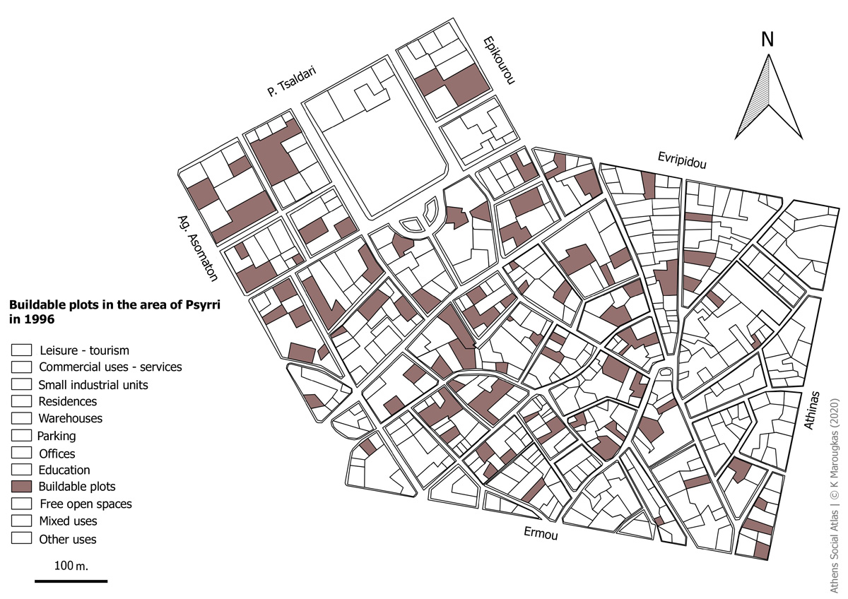
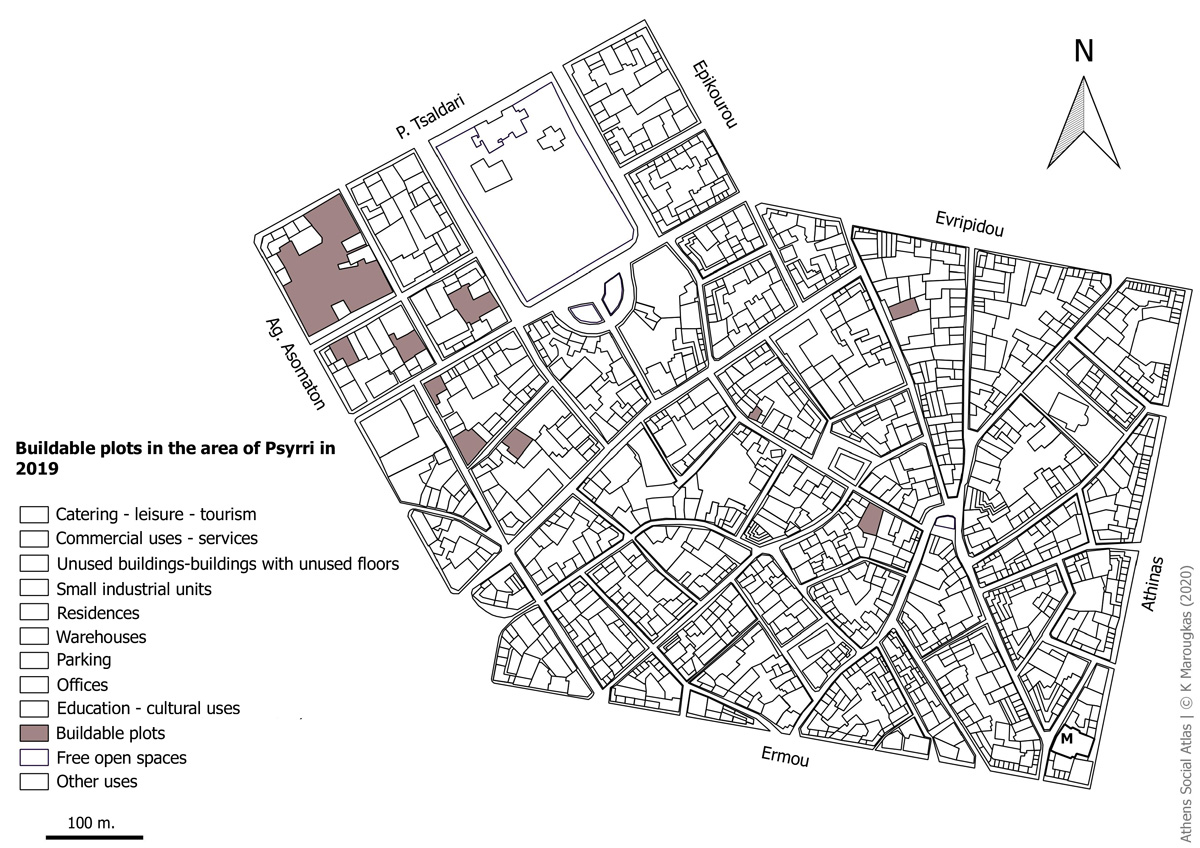
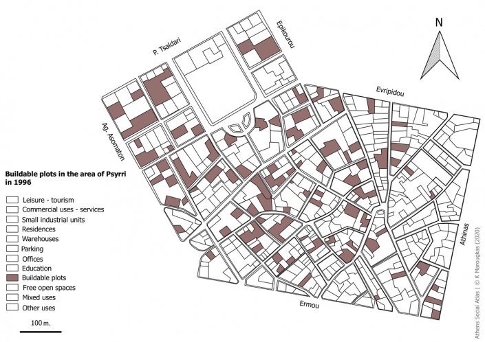
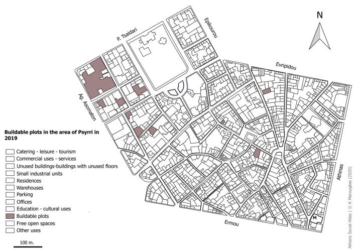
A comparison of the buildable plots in Psyrri area , reveals significant changes between 1996 and 2019 (Maps 4 and 5). In 1996, the buildable plots were one of the main categories and were located throughout the area
More specifically, in 1996, about 70 plots were identified in the area, several of them of significant size, while in 2019, only ten plots were located in the area. Buildings with a variety of land uses, are being erected today in many of those plots. The largest buildable plot is currently located in the northwest and it almost covers an entire building block. The remaining buildable plots are of limited size and are “cramped” in a dense urban fabric.
Map 4: Buildable plots in the area of Psyrri in 1996
Source: ELSTAT basemap, Αttiko Μetro 1996, Author
Map 5: Buildable plots in the area of Psyrri in 2019
Source: ELSTAT basemap, Author
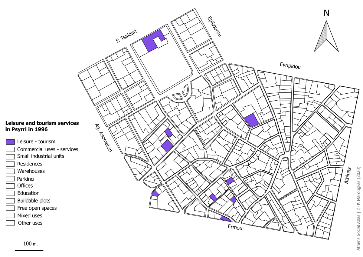
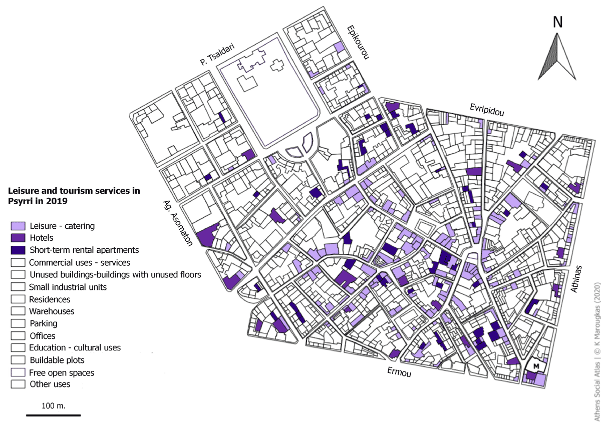
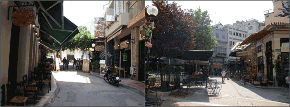
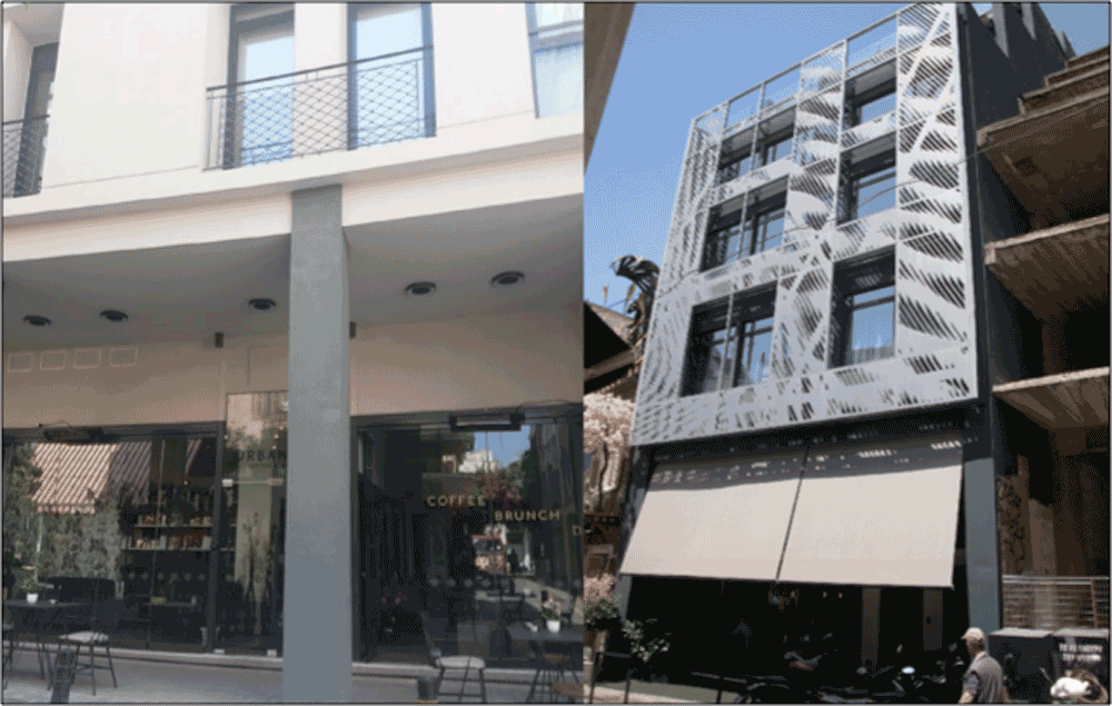
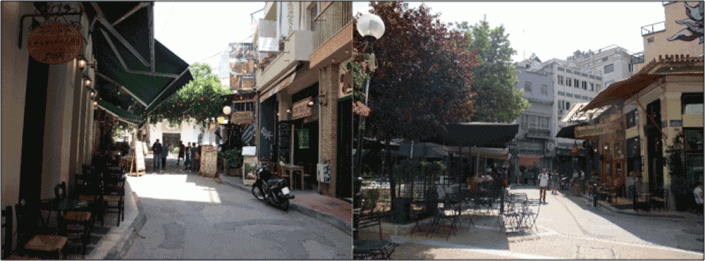
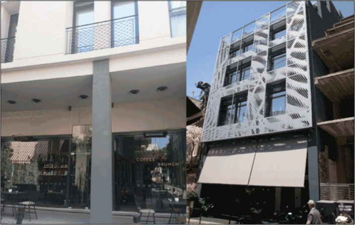
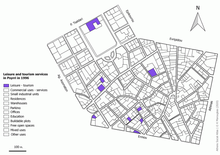
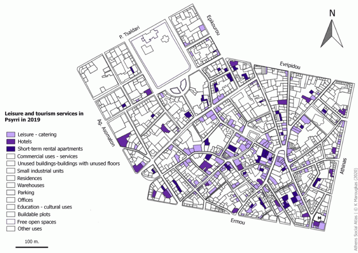
The biggest change over the years can be observed in leisure and tourism services. In 1996, the buildings few buildings hosted leisure and tourism activities. On the contrary, in 2019, leisure and tourism services are among the top land uses in the area. Restaurants, bars, café are prevalent around the Iroon Square, on the East side and further South. The companies who clustered in Psyrri, are small and have the same aesthetic and cultural identity. They belong to businessmen, many of whom, in the past, did not engaged in leisure professional activities (Σουλιώτης 2009). Also, scattered throughout the area are a significant number of hotels and a growing number of short-term rental apartments. Some old buildings have been completely renovated and have been converted into tourist accommodation. These buildings are located mainly on streets with shops, restaurants and coffee-bars.
These short-term rental apartments are located either on residential floors, in buildings used as warehouses or in empty buildings that have no other use. The number of those apartments in the area is large and constantly increasing. The character of the area, focused mainly on catering, leisure and tourism services, combined with the area’s location makes it ideal for hotels and short-term rentals.
Map 6: Leisure and tourism services in Psyrri in 1996
Source: ELSTAT basemap, Αttiko Μetro 1996, Author
Map 7: Leisure and tourism services in Psyrri in 2019
Source: [2]
Photo 2: Restaurants, bars, café are prevalent in and around the Iroon Square
Source: Author 2019
Photo 3: Short-term rental apartments (on the left) and hotel (on the right) in Karaiskaki Street, which combined with catering-leisure services
Source: Author 2019
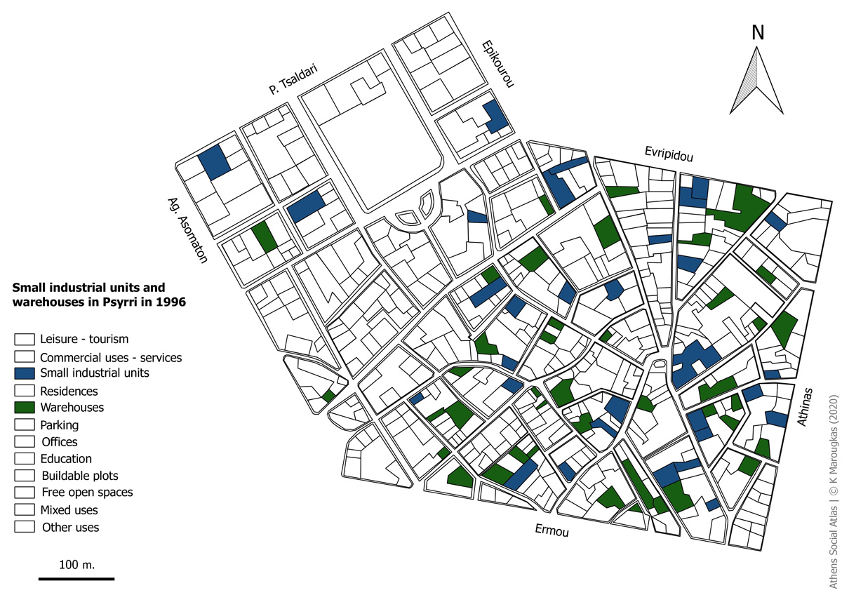
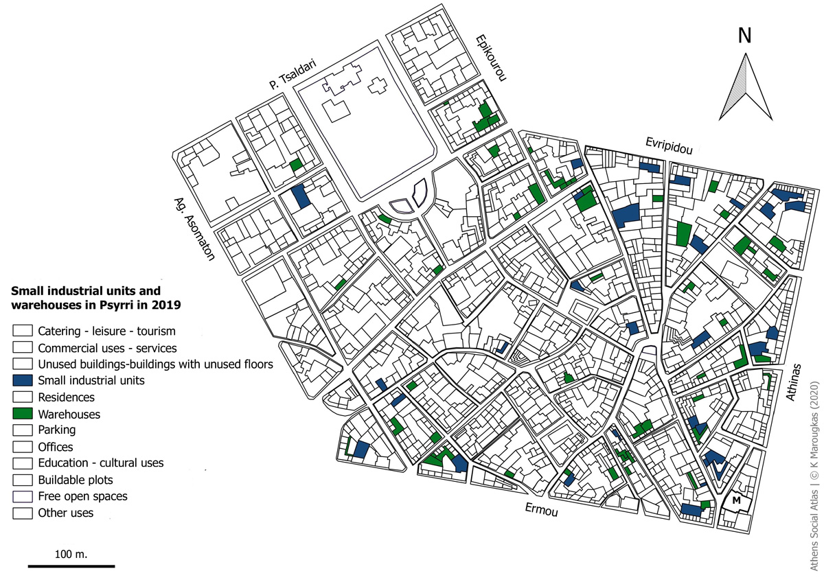
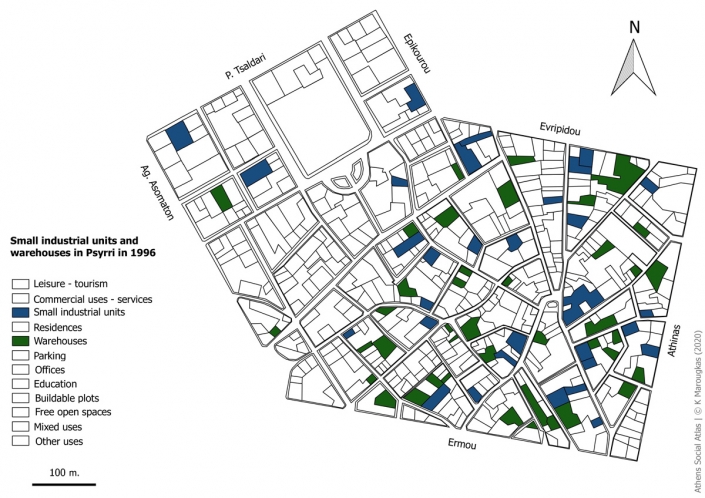
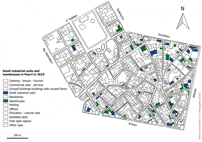
Since 1996, the craft shops and warehouses are concentrated in the area circumscribed by Sarri – Evripidou – Athinas – Ermou streets. To this day, they are still found in this section, mainly along the perimeter roads. Catering, leisure and tourism services as well as trade shops are clustering in the centre of that quarter where a large number of unused buildings also exist.
Manufacturing (handicrafts or industry), and generally the productive activities of the secondary sector, have been in constant crisis in the center of Athens since the 1970’s. A number of policies, plans and measures, have removed those activities from the area, due to environmental degradation (Βασιλοπούλου και Τριάντης 2012) and overall, due to the incompatibility with the desired character of the Historic Center. The policy goal for the centre was to become a “theme park” for the development of “mass” tourism (Μαντουβάλου 2010). More specifically, in the area, policies for the removal of small industry were promoted, through the Regulatory Plan of 1985, as well as through the Presidential Decree for the areas of Omonia – Psyrri [3]. These policies however, did not manage to attract residential uses (Βασιλοπούλου και Τριάντης 2012).
Nowadays, a limited number of small industrial units are located in the area of Psyrri, as well as several apartment buildings which accommodate warehouses (Βασιλοπούλου και Τριάντης 2012). As shown on Map 9, the majority of warehouses are located on the upper floors of such buildings. Many of these buildings are vacant or devalued and are often occupied by immigrants, homeless people and/or drug addicts.
Map 8: Small industrial units and warehouses in Psyrri in 1996
Source: ELSTAT basemap, Αttiko Μetro 1996, Author
Map 9: Small industrial units and warehouses in Psyrri in 2019
Source: ELSTAT basemap, Author
Photo 4: Warehouses located on the upper floors of apartment buildings in Agias Theklas street
Sourse: Author 2019
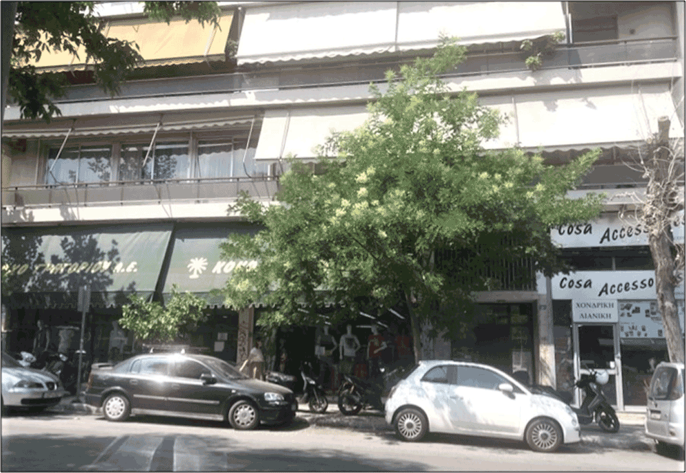
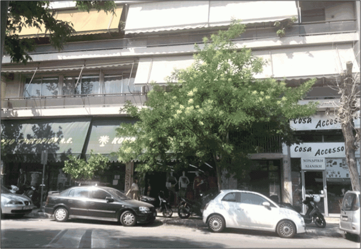
Residences have strong presence in 1996 and 2019 throughout the area (Maps 10, 11). Psyrri is designated as a ‘mixed use’ residential area (not ‘single use’), with residential buildings now hosting commercial shops on their ground floors.
The differences in quality , are also related to the uses that residential buildings accommodate. For example, residences in the area’s center, are combined with catering-leisure and tourism uses and thus, most of the buildings are in good condition. On the contrary, residences located north of Iroon Square towards Evripidou Street, are in poor condition, in disrepair and are vacant to a significant extent.
Map 10: Residences in Psyrri in 1996
Source: ELSTAT Basemap, Αttiko Μetro 1996, Author
Map 11: Residences in Psyrri in 2019
Source: ELSTAT basemap, Author
Photo 5: Apartment building with commercial shops on the ground floor in Koumoundourou Square
Source: Author 2019
Trade and services have historically been an important land use category in the area. In maps 12 and 13), we note that commercial and services land uses, are present throughout the area. Trade (especially retail), is an important economic sector in the area, now coexisting, with leisure and tourism services. This is an activity, mainly taking place on the ground floor. However, despite the steady presence of commercial activity in the area, the percentage of closed stores is not negligible today.
Map 12: Commercial uses-services in Psyrri in 1996
Source: ELSTAT basemap, Αttiko Μetro 1996, author
Map 13: Commercial uses-services in Psyrri in 2019
Source: ELSTAT basemap, author
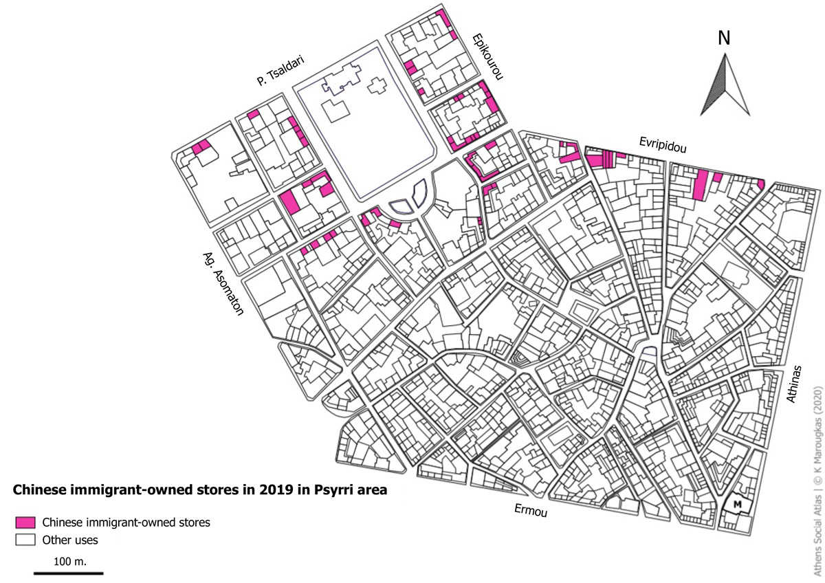
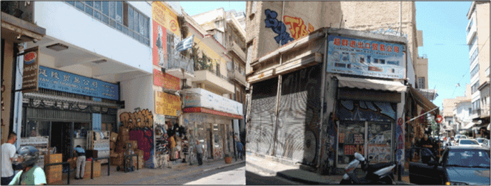
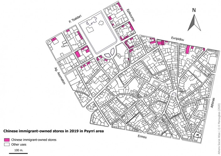
Meanwhile, changes in local population composition, with the strong presence of immigration groups, has brought some significant changes in trade, as many stores have now passed into immigrants hands. The so called “ethnic trade” is found mainly in northern and western parts of Psyrri area, on streets as Evripidou and Epikourou, as well as on the streets around Koumoundourou Square.
A typical example, is Chinese immigrants’ shops (Map 14). The emergence and rapid growth of “China Town” is a phenomenon of the early 2000s, with the Chinese market developing on the eastern side of Metaxourgio, up to Omonia Square, crossing over to Psyrri and around Koumoundourou Square (Βασιλοπούλου και Τριάντης 2012). Chinese immigrants in Athens, specialize in retail and wholesale trade, supported by the “supralocal” clientele of these stores, which sell mainly, wholesale clothes, footwear and accessories. The Chinese traders presence, has significantly affected the business spaces’ rental market and inflated rental prices, especially on the borders between Metaxourgio and Piraeus Str. (Πολύζου 2014).
Map 14: Chinese immigrant-owned stores in 2019 in Psyrri area
Source: ELSTAT basemap, author
Photo 6: Chinese immigrant-owned stores at Evripidou street 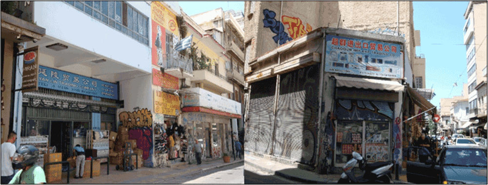
Source: Author 2019
Population changes
The analysis of National Census data (ΕΛΣΤΑΤ – ΕΚΚΕ 2019) shows that the population of the area has changed significantly over the years (Table 1). In 2001, it increased by 21,53% compared to 1991. The presence of Greeks, although declining, remains strong, while the presence of foreign nationals increased significantly. In the early 1990s, a significant number of immigrants settled in the country and found shelter in places abandoned by small industry or in former warehouses or in degraded residential buildings in small ground floor, and basement flats (Μαλούτας 2018, Μαντουβάλου 2010). In this context, a significant number of immigrants gathered in Psyrri and thus, its total population increased in 2001, contrary to the Municipality of Athens, where the total population decreased significantly (ΕΛΣΤΑΤ – ΕΚΚΕ 2019).
In the 2011 census, the population of Psyrri appears to have significantly declined by 40% (ΕΛΣΤΑΤ – ΕΚΚΕ 2019). As in the entire Municipality of Athens, the overall population decline in the area, may be due, in the first place, to the intense and multidimensional degradation of the wider city center, which pushed existing residents to the suburbs and prevented the settlement of new ones (Μαλούτας κ.ά. 2013).
At the same time, in many areas of the city center, we can see a change in land uses which now focus in consumption, trade and entertainment. The removal of other functions and the orientation of the Historic Center in the development of “mass” tourism, reduces the attractiveness of the Center for the permanent residents, especially for the social strata that were served well by previous land uses (Μαντουβάλου 2010). The Psyrri district, in particular, due to the removal of manufacturing activities, during the 1980s and 1990s, has changed significantly (Βασιλοπούλου και Τριάντης 2012).
Table 1: Population of Psyrri in 1991, 2001 and 2011
Source: ΕΛΣΤΑΤ – ΕΚΚΕ 2019, own processing
Finally, through the data of the National Census (ΕΛΣΤΑΤ – ΕΚΚΕ 2019), it appears that, in 2011, the number of foreign nationals in the area is significant and constitutes 47.17% of the population. (Table 2). The area brings together ethnic groups from different countries, although, many of them are, of course, represented by an extremely low number of people. It’s typical, that in 2011, the 38 countries with the lowest representation, have a single-digit number of people. Among the many immigrant groups, the highest number of people, in 2011, had Bangladeshi and Albanian nationalities (together they accounted for 52.59% of all foreign nationals in the area), while two migrant groups that are emerging and gradually growing, are Chinese and Afghans. There were no Chinese in the area in 1991, while, in 2001, 21 people were registered there, and in 2011 that number rose to 79. It is characteristic, that the area’s total population is decreasing, as is the number of people fromall ethnic groups, with the exception of the Chinese (who increase) and the Afghans (who appear for the first time).
Table 2: Selected Ethnic groups in Psyrri in 1991, 2001 and 2011.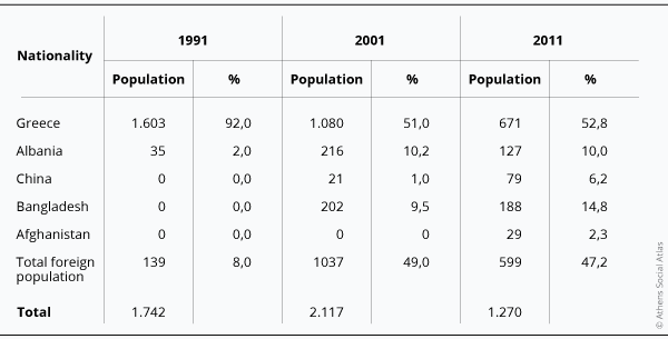
Source: ΕΛΣΤΑΤ – ΕΚΚΕ 2019, author.
The interventions taking place at present and the new land uses, are mainly related to catering services, leisure and tourism. The geographical concentration of this type of companies, aims to create a cluster so the area could be attractive to consumers (Σουλιώτης 2009).
At the same time, housing hasbeen adversely affected, till today, as it is a use that is vulnerable to pressures from other uses.
Finally, migrant groups have a strong presence mainly in northern and western parts of the area, and more specifically, north of Iroon Square up to Evripidou Str. and eastern of Sarri Str. up to P. Tsaldari Str. With their presence and activities, these groups, have contributed to the upgrade of buildings with improvement and conversion projects (Μπαλαμπανίδης και Πολύζου 2015). At the same time, people of various income groups coexist without particular tensions.
[1] ELSTAT did not have a buildings level basemap for 2011, which was the most recent census year.
[2] Source: ELSTAT basemap, Author, https://www.airbnb.gr/, https://www.booking.com/index.el.html, https://www.boutiqueathens.com/, https://www.hotelsathens.org/
[3] ΦΕΚ/ Government Gazette Δ 233/1998, Determination of land uses and special terms and construction restrictions in the area of Psyrri – Center (Omonia) of the Athens road plan, 9/4/1998.
Entry citation
Marougkas, K. (2020) The evolution of land uses and population in Psyrri district, in Maloutas T., Spyrellis S. (eds) Athens Social Atlas. Digital compendium of texts and visual material. URL: https://www.athenssocialatlas.gr/en/article/psyrri-district/ , DOI: 10.17902/20971.99
Atlas citation
Maloutas T., Spyrellis S. (eds) (2015) Athens Social Atlas. Digital compendium of texts and visual material. URL: https://www.athenssocialatlas.gr/en/ , DOI: 10.17902/20971.9
References
- Πολύζου Ί (2014) Μεταναστευτικές διαδρομές και χωροκοινωνικές μεταλλαγές στην Αθήνα. Η περίπτωση των Κινέζων εμπόρων στο Μεταξουργείο. Επιθεώρηση Κοινωνικών Ερευνών 143: 145–152. Available from: https://ejournals.epublishing.ekt.gr/index.php/ekke/article/view/7687/7405.
- Μπαλαμπανίδης Δ και Πολύζου Ί (2015) Αναχαιτίζοντας τάσεις εγκατάλειψης του αθηναϊκού κέντρου: η παρουσία των μεταναστών στην κατοικία και στις επιχειρηματικές δραστηριότητες. Στο: Μαλούτας Θ και Σπυρέλλης ΣΝ (επιμ.), Κοινωνικός Άτλαντας της Αθήνας. Ηλεκτρονική συλλογή κειμένων και εποπτικού υλικού, Αθήνα. Available from: https://www.athenssocialatlas.gr/άρθρο/μετανάστες-κατοικία-και-επιχειρήσει/#3.
- Μαντουβάλου Μ (2010) Κρίση του Κέντρου της Αθήνας. Στο: Κέντρο και Κεντρικότητες, Παρίσι – Αθήνα: Συγκρίσεις, Αθήνα.
- Σουλιώτης Ν (2009) Πολιτιστικές στρατηγικές και αστική αναζωογόνηση στο ιστορικό κέντρο της Αθήνας: τοπικές συνθήκες και παγκόσμιες τάσεις. Στο: Κοτζαµάνης Β, Κούγκολος Α, Μπεριάτος Η, κ.ά. (επιμ.), Πρακτικά του 2ου Πανελλήνιου Συνεδρίου Πολεοδομίας, Χωροταξίας και Περιφερειακής Ανάπτυξης, Βόλος: Εκδόσεις Πανεπιστημίου Θεσσαλίας, σσ 665–674. Available from: https://www.academia.edu/2268740/Πολιτιστικές_στρατηγικές_και_αστική_αναζωογόνηση_στο_ιστορικό_κέντρο_της_Αθήνας_τοπικές_συνθήκες_και_παγκόσμιες_τάσεις.
- Εμπορικός Σύλλογος Αθηνών (ΕΣΕΕ) (2017) Η καταγραφή των κλειστών καταστημάτων καταδεικνύει μια παγιωμένη εικόνα στην αγορά της Αθήνας. Available from: https://www.esathena.gr/index.php/el/esee-e-katagraphe-ton-kleiston-katastematon-katadeiknyei-mia-pagiomene-eikona-sten-agora-tes.
- Βασιλοπούλου Χ και Τριάντης Λ (2012) Κεντρικότητες και δυναμικές των χρήσεων στο κέντρο πόλης Αθήνας. Στο: Τουρνικιώτης Π (επιμ.), Μεταλλασσόμενοι χαρακτήρες και πολιτικές στα κέντρα πόλης Αθήνας και Πειραιά [A΄ Φάση], Αθήνα, σσ 105–145. Available from: https://www.academia.edu/8996307/Κεντρικότητες_και_δυναμικές_των_χρήσεων_γης_στο_κέντρο_πόλης_Αθήνας.
- Καιροφύλας Γ (2000) Η ιστορία της συνοικίας του Ψυρή. Αθήνα: Φιλιππότης.
- Μαλούτας Θ, Κανδύλης Γ, Πέτρου Μ, κ.ά. (2013) Εισαγωγή: Η επαναφορά του ζητήματος του κέντρου της Αθήνας στην ημερήσια διάταξη. Στο: Μαλούτας Θ, Κανδύλης Γ, Πέτρου Μιχάλης, κ.ά. (επιμ.), Το κέντρο της Αθήνας ως πολιτικό διακύβευμα, Αθήνα: Εθνικό Κέντρο Κοινωνικών Ερευνών, σσ 11–25.
- Μαλούτας Θ (2018) Η κοινωνική γεωγραφία της Αθήνας. Κοινωνικές ομάδες και δομημένο περιβάλλον σε μια νοτιοευρωπαϊκή μητρόπολη. Αθήνα: Αλεξάνδρεια.
- ΕΛΣΤΑΤ – ΕΚΚΕ (2019) Πανόραμα Απογραφικών Δεδομένων 1991-2011. Available from: https://panorama.statistics.gr/.
