Initial planning and current situation of refugee housing and outdoor public spaces in the post-refugee urban settlement of Nikea in Attica
Toussi Evgenia
Built Environment, Planning, Quartiers
2024 | Jan
The area of Nikea in Attica, is inextricably linked to the refugee urban rehabilitation of 1922. It is today one of the refugee settlements that retains a large percentage of its old buildings. These buildings belong to different architectural types, they are either single-storey or two-storey, with a small apartment area and many arbitrary extensions/additions. Important is the fact that they have not been included in a conservation/protection regime. Specific building types include a large number of abandoned apartments, creating conditions of decay in specific enclaves within the neighborhood, raising concerns about the future of the area in terms of collective memory. Of particular interest is the original design of the area, which includes a network of intermediate spaces in the city blocks combined with passageways, which under certain conditions can function as a network.
Introduction
The refugee issue of 1922 was a turning point in the Greek history of the 20th century, as it was associated with a vast demographic change in the country. After the Greco-Turkish War (1919–1922), the Lausanne Treaty in 1923 led to the mandatory exchange of populations in Greece and Turkey (Εξερτζόγλου, 2016: 343). Based on historical evidence (Clark, 2009: 11), more than 1,200,000 Orthodox Christians and 400,000 Muslims were forced to leave their homes and settle in Greece and Turkey respectively. The experience of violent expatriation, the traumatic memories of the catastrophic fire in Smyrna, and the efforts to integrate into the new homelands, defined profoundly the contemporary Greek identity (Παπαδόπουλος, 2013: 335-336).
Integration efforts were directly related to the issue of housing. Initially, on September 15, 1922, the ministerial decision “On confiscation of real estate for the settlement of refugees” and the relevant law that was enacted shortly after, attempted to provide a temporary solution to the housing issue. The inadequacy of this measure led to the creation of the Refugee Treatment Fund in November 1922, which operated until 1925 and was active throughout the country (Γκιζελή, 1984: 132-140). Then, in 1925, the Refugee Rehabilitation Committee was established, under the general supervision of the United Nations (Χίρσον, 2004: 114 και Γκιζελή, 1984: 156). The Refugee Relief Committee, with the aim of permanent settlement, grouped the refugee population into “urban” and “rural”, depending on the place of origin. Based on this classification the Committee directed the refugee population to urban and rural areas respectively (Γκιζελή, 1984: 178). The Refugee Relief Committee tried to achieve a smooth integration of the refugee population into the existing social conditions, through securing housing and work. In rural settlements, the issue was resolved through the allocation of agricultural land. In the cities, the issue was not resolved collectively, with the Committee to finally emphasize on housing rehabilitation (Τούση, 2014: 55-57). Noteworthy is the fact that before the refugee inflow, there was no policy for social housing, despite the already identified needs of vulnerable population groups. (Γκιζελή, 1984: 14, 123).
The first urban refugee settlements were located outside existing city limits (Σαρηγιάννης, 2000: 104), at a distance of 1 to 4 kilometers (Λεοντίδου, 1989: 209). This planning decision had an evident social impact. For many decades, the refugee population had been subject to discrimination and social exclusion, living in urban forms with a lack of social infrastructure (Λεοντίδου, 2001: 216; Χίρσον, 2004: 117; Κουτελάκης κ.α., 1991:171; Pentzopoulos, 1962:12).
Over the years, the physiognomy of the refugee areas began to change, especially after 1960 and the spread of the flats-for-land system, where the building stock was gradually replaced (Τούση, 2014: 40). Despite the socio-spatial transformations that occurred through the lapse of time, a significant number of the post-refugee areas retain elements reminiscent of the refugee past (street plan, refugee homes, street names, monuments). From this point of view, the example of Nikea is a typical example. The analysis below adumbrates the socio-spatial evolution of the area, highlighting critical contemporary issues.
Brief overview of the initial formation of the settlement of Nikea
One of the largest urban refugee settlements, the Nikea settlement, is inextricably linked to the rehabilitation of the Asia Minor refugees of 1922, since before their settlement, the area was practically uninhabited (Χίρσον, 2004: 114; Παπαδοπούλου, 2003: 67). Its first inhabitants were Armenians, who settled at the southernmost end of the settlement in 1923 on the border with Palia Kokkinia (Παπαδοπούλου, 2003: 65). Then in the same year, refugees from Asia Minor settled. The establishment of the settlement is attributed to Epaminondas Harilaou, First Vice-President of the Refugee Relief Committee (Παπαδοπούλου, 2003: 7).
The location was named “Nea Kokkinia” and until 1934 it belonged to the municipality of Piraeus. On 18-12-1939 it was renamed, following a competition, to Nikea, from Nikea of Bithynia, a city in northwestern Asia Minor. The name Kokkinia is not directly connected with the refugee settlement and the culture of Asia Minor.
In early 1923 the Refugee Relief Fund mapped the area with the aim of proceeding to housing construction. At first the accommodation was in temporary accommodation (tents) and then houses with an extremely small area (5×4 m or 6×4 m, Χίρσον, 2004: 114). Excerpts from the daily press of the period 1928-1932 refer to Kokkinia, describing the poor medical care, the absence of latrines, the high population density, the lack of connection to the water supply network and the lack of artificial lighting on the streets. In the census of 1928, 33,201 inhabitants were recorded, but the daily press of the time states that the population ranged from 45 to 50 thousand people (Κουτελάκης et al, 1991: 171)
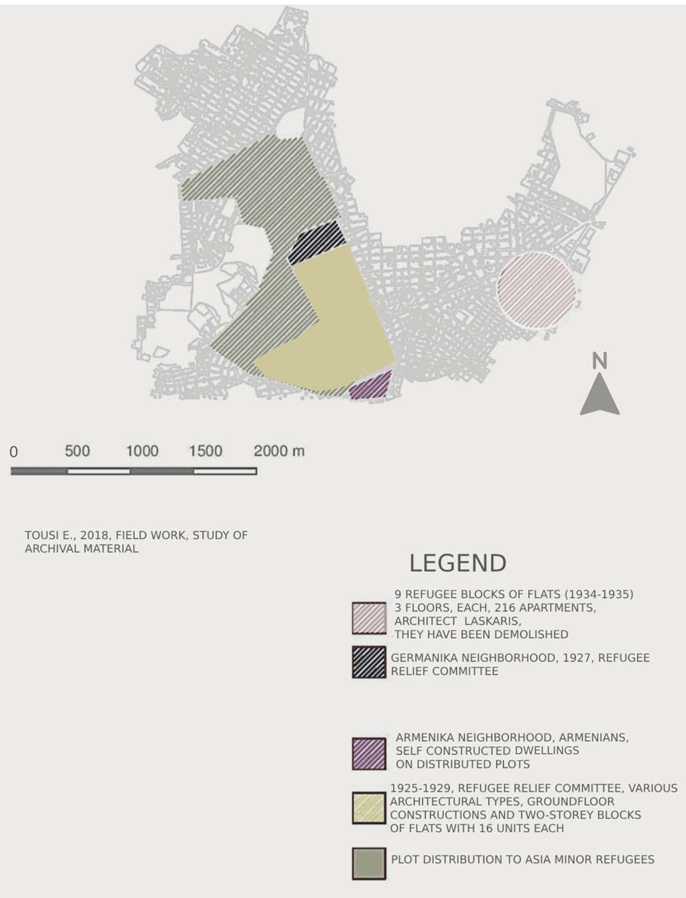
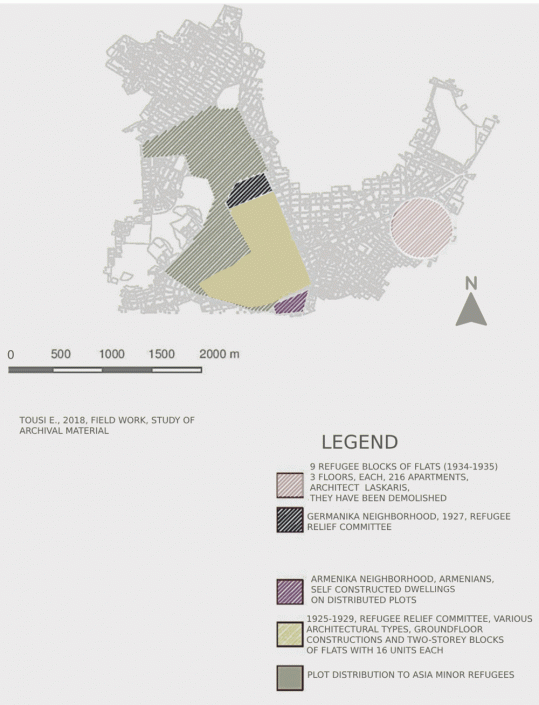
In the next 5 years, the Refugee Relief Committee proceeded with systematic planning of the area and the construction of houses of various architectural types (Παπαδοπούλου, 2006:7 ; Χίρσον, 2004: 114). These houses belong to different architectural types as presented in section III hereof. The initial housing phase (1924-1926) covered the area of Osia Xeni and Ag. Nikolaou (Χίρσον, 2004: 114). In the period 1925-1926 the activity of the Committee culminated in shaping the majority of the neighborhood’s building blocks (Χίρσον, 2004: 115). In 1927, following a second international loan, the Germanika district was formed (ibid.) According to relevant sources, the last attempt to rehabilitate refugees in the area, dates back to 1934 and 1935, with the construction of apartment buildings by the Ministry of Social Welfare (Χίρσον, 2004: 116). These are the apartment buildings that were demolished, after the 1981 earthquake, giving the space to the General Hospital of Nice “Saint Panteleimon”. Retracing on the activity of the Refugee Relief Committee in Attica from 1926 to 1930, a total of 5,584 houses was constructed in the settlement of Kokkinia (Λεοντίδου, 1989: 211). In the book “Piraeus and Settlements” (Κουτελάκης, 1991: 172) the names of the engineers Dionysios Kokkinos and Alex. Fatseas are mentioned, who worked for 4 years in the settlement in order to complete the refugee housing. Since then, the settlement continued to expand through the granting of plots, but the construction of the residence was now carried out by the refugees themselves (see Figure 1) (Χίρσον, 2004: 116).
As stated by Mich. L. Rodas in the “Chronicles of Nikaia” (Παπαδοπούλου, 2003: 7) the refugees who bought their own residence paid 1/10 of the value and 8% interest. According to the study of allowances by the Department of Social Welfare of the Attica Region, it was found that the amount varied according to the type of residence and ranged from 18,000 to 24,000 drachmas [1]. Apart from the unfavorable housing conditions, another key issue was the connection of the area to the rest of the urban fabric. In 1936, the Ministry of Transport with the Act 279/20-2-1936, approved public transportation between Piraeus and Aspra Chomata (a neighborhood in Nikea) (Παπαδοπούλου, 2003: 13, 56).
Figure 1: Map of Nikaia with different types of refugee rehabilitation
Source: Toussi E. 2018, study of archival material Technical Service of the Municipality of Nikaia-Ag.I.Renti and Department of Social Assistance, Region of Attica, source of map-background Technical Service of the Municipality of Nikaia-Ag.I . Renti
Concerning the social synthesis of the area, its first inhabitants were primarily Armenians and refugees from Asia Minor. These inhabitants came from different areas of Asia Minor and belonged to different levels of socio-economic stratification (Παπαδοπούλου, 2003: 6; Χίρσον, 2004: 302). Given the social and geographical isolation of the settlement, social networks were developed, which were strengthened by marriages and spiritual affinities. According to Hirschon (2004: 82), these networks mainly concerned Asia Minor refugees, while contacts with Armenians were limited. However, the harmonious coexistence and mutual respect are highlighted (ibid.). These social networks were reflected in the use of public space, in the city’s microscale. The conscious character of this social interaction, was also due to the organization of Asia Minor society in different districts based on the nationality of the population (Χίρσον, 2004: 304 et 80-82, Armenian quarter, Jewish, Turkish, Greek Orthodox etc [2] ). The nexus of these relationships was also strengthened by the endowment of daughters, which led to a female dominance in the geographical space. Thus, the refugee households had kinship ties from the woman’s side (matrilocal, matrilocality, Λεοντίδου, 1989: 246). The daily social interaction was also reinforced by an intermediate multi-functional space in the refugee blocks, which expressed the blurring of the boundaries between public and private space (Νικολαϊδου, 1991:83).
The settlement of new residents after the Second World War, combined with the expansions of the city plan, diversified the existing balances, eliminating social exclusion (Τούση, 2014: 316). The internal immigrants of the 1950s and 1960s moved to the boundaries of the settlement, expanding them, building arbitrary ground-floor houses (ibid.). After the 1970s and the heyday of the flats-for-land system, the original character of the refugee settlement has significantly changed. This is owed not only to the changes that occur in the built environment but also to the gradual establishment of new social standards (ibid.).
Urban planning of the area and prevailing architectural types
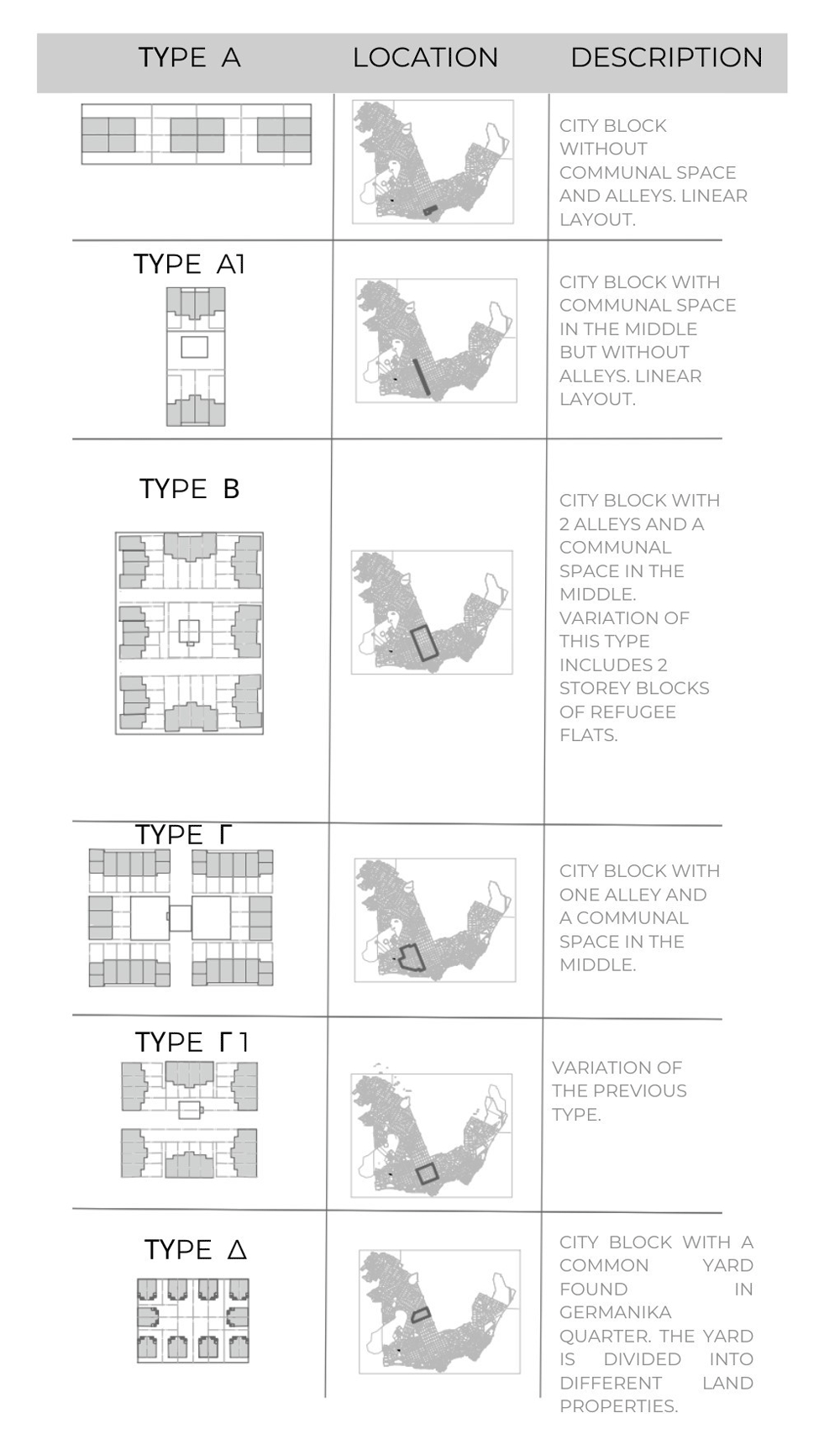
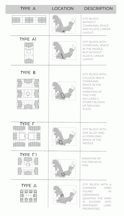
The arrival of the Asia Minor refugees led to extensive expropriations in the region. The refugee settlement followed an Hippodamian grid, including four different types of city blocks (Figure 2). The city blocks were mostly designed with a common outdoor space in the middle and one or two alleys. In very few cases, city blocks are found without passageways and shared outdoor space.
Figure 2: Types of city-blocks in the refugee settlement of Nikea
Source: Field work and study of archival material, Tousi, 2011 and 2014
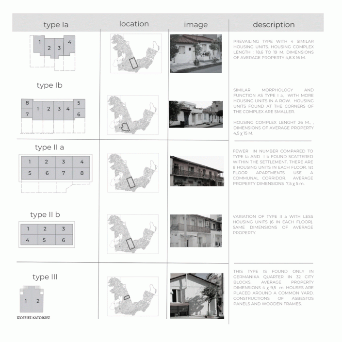
Field work identified three main different types of refugee housing, as shown in Figure 3. These are ground floor and two-story structures, with tiled roofs, offering a small residential area. The predominant type is I a, which includes repetition of four identical housing units. The two-story complexes (II a and II b), which are fewer in number, can be found scattered throughout the settlement.
Figure 3:Grouping of the architectural types of housing identified in the study area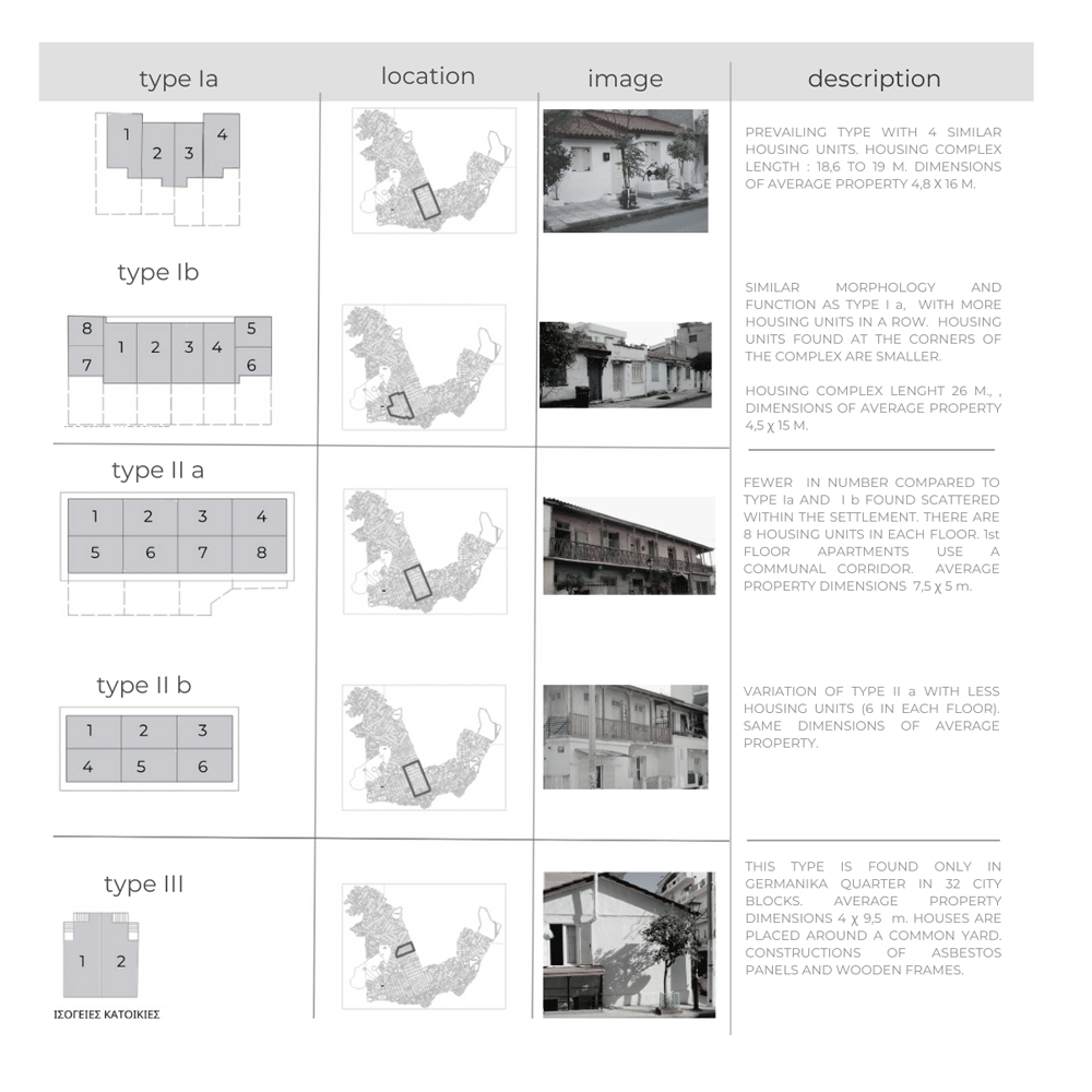
Source: Primary research
Note: for the formation of the table, a study of the original cadastral diagrams was carried out, confirmation of dimensions / mapping of existing buildings, identification of the location of the buildings in the area, photographic documentation and digital design, Toussi E., 2011-2019
Based on archival material (initial distributions and cadastral charts) and field work, each city block in the refugee settlement of Nikaia is a separate case study. The causes of this complexity should be sought in the original design of the settlement.
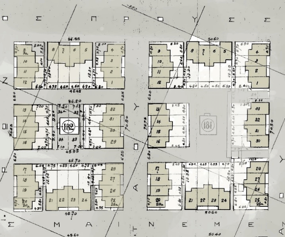
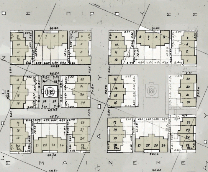
Figure 4: Case of city block no. 182 and no.181. In 182 the intermediate space is divided and bears a property number, while in the case of the 181 it isn’t
Source: Technical Service of the Municipality of Nikias-Ag.I. Rentis, Topographical Department, author’s work
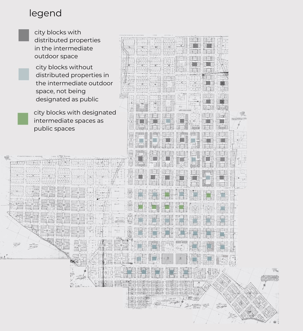
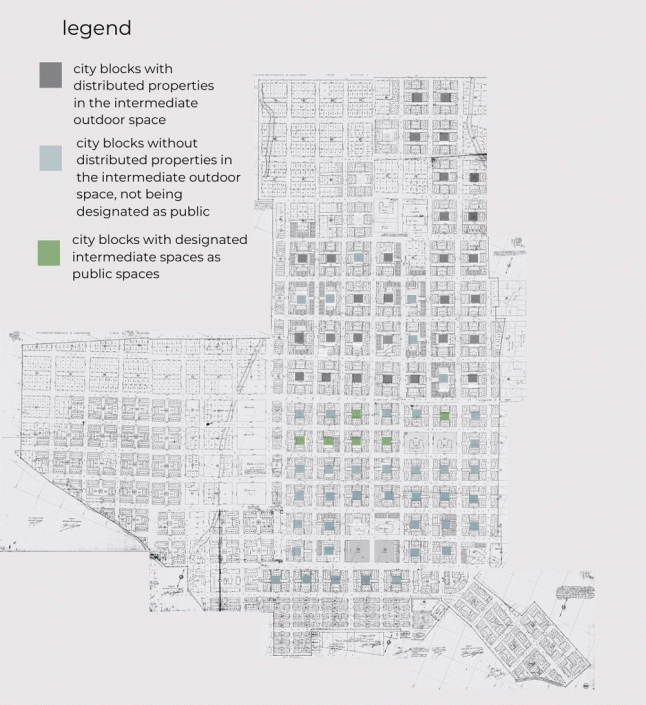
As illustrated in the excerpt of the cadastral diagram, (Figure 4), the intermediate space in the city blocks, was in some cases, not originally designated as public outdoor space. In fact, in several cases it carried property numbering and relevant markings, indicating the division of properties (Figure 5). Old facilities (laundries) constructed in the center of the blocks were later demolished, giving way to further spatial transformations.
Figure 5: Intermediate outdoor spaces in the city center of the refugee settlement of Nikea, illustration of designated outdoor public spaces in initial distributions and other cases
Source: Compilation of individual cadastral maps and marking of areas after studying archival material by the Department of Social Welfare, Region of Attica, author’s work
Current situation of refugee buildings
According to field work, the refugee apartments in Nikea have a small area of 30 to 60 sq.m. and many arbitrary additions both to the building itself and to the outdoor public space. Today, official building guidelines, require a minimum plot face of 6 m and a minimum total surface of 110 sq m. The new constructions move at a significantly higher height compared to the two-story or single-story refugee houses, creating a non-homogeneous cityscape. This fact has significant effects on the environmental response of the buildings such as unwanted mutual shadows, insufficient natural lighting and ventilation.
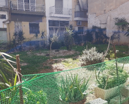
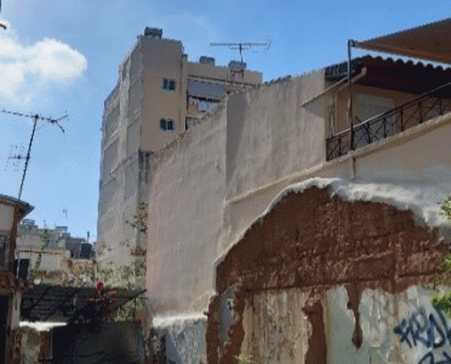
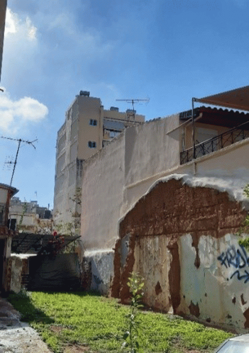
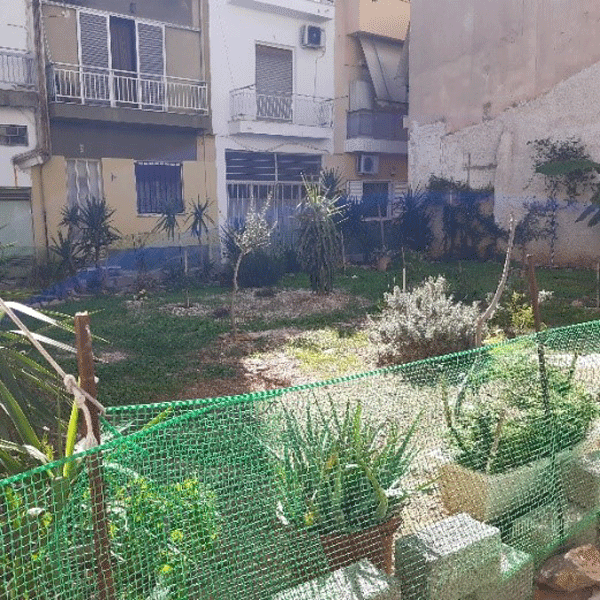
The majority of the old refugee houses have not been efficiently maintained, resulting in serious damage to the load-bearing body. Demolitions of refugee complexes were rare until the years 2018-2019 (two in ten years). In recent years (2019-2023) demolitions are becoming more frequent and mainly concern ground-floor refugee buildings (Photo 1 & 2). A significant number of the refugee houses in Germanika Quarter has been demolished [3], the rest of the architectural types are found in moderate state of maintenance. Noteworthy is the fact that the remaining refugee houses have not been included in a protection/preservation regime.
Photo 1 & 2: Recent refugee buildings demolitions
Source : field research, Tousi 2021
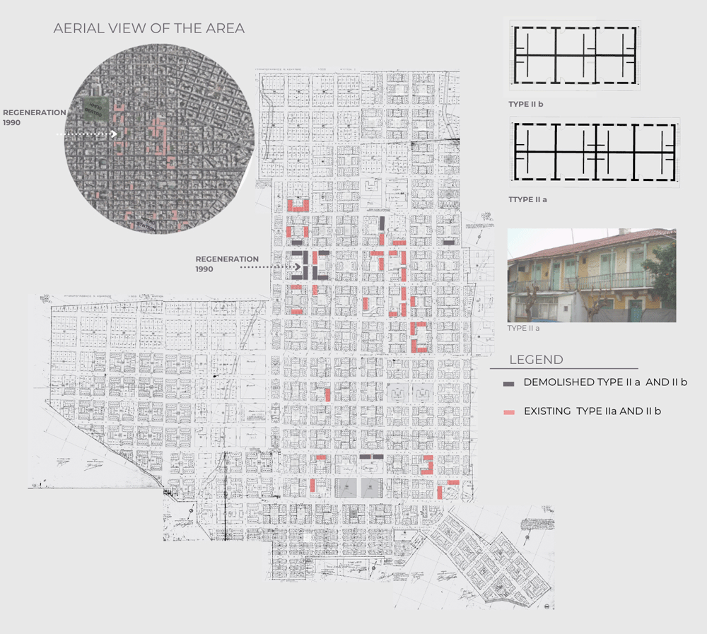
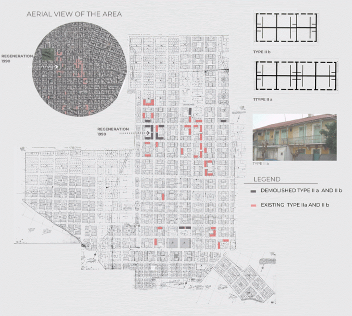
Figure 6: Comparison of today’s aerial photograph of the area with the original distribution map (composition of a map by combining individual cadastral sheets). Marking of the existing two-story refugee houses as well as those that were demolished.
Source: List of floor plan sketches of these architectural types, field work and mapping, author’s work
In many cases the two-story refugee housing complexes (Type IIa) are found derelict with many abandoned apartments. As depicted in Figure 8, very few complexes of this type have been demolished, four of which were included in the municipality’s regeneration program in the 1990s. A key issue for type II is the number of heirs, which acts as a barrier to decision-making. It is also noteworthy that parts of the complexes or even individual apartments, have been adequately preserved, coexisting with apartments that have been left in despair.
According to testimonies of residents (Toussi, 2014: 470), in the 1980s, the first-floor apartments in the type II were the first to be abandoned. This phenomenon was related to the shared external corridor, which significantly reduced the sense of privacy in the apartments on the first floor.
Current state of intermediate outdoor spaces in the city blocks of the refugee settlement
The original design of the city blocks ensured the existence of an intermediate public space, which proved determinant for the social networks of the area. After the 1980s, the demolition of the refugee complexes and the construction of apartment buildings changed the quality and number of outdoor spaces in the area. It is important to mention that the municipality proceeded in a regeneration of these intermediate spaces in some of the blocks during the 1990s and recently. The ownership regime in these areas is extremely complex, especially in the cases of several heirs, in areas that were initially distributed to refugees, beneficiaries of rehabilitation. Today, several of these sites belong to the Greek State, while a significant number belongs to an unknown owner. Another key issue is the arbitrary expansions on these spaces, and also various plot annexations that are still unresolved. According to field work findings, a gradual weakening of social relations at the neighborhood level has been observed.
Elements of collective memory in the area
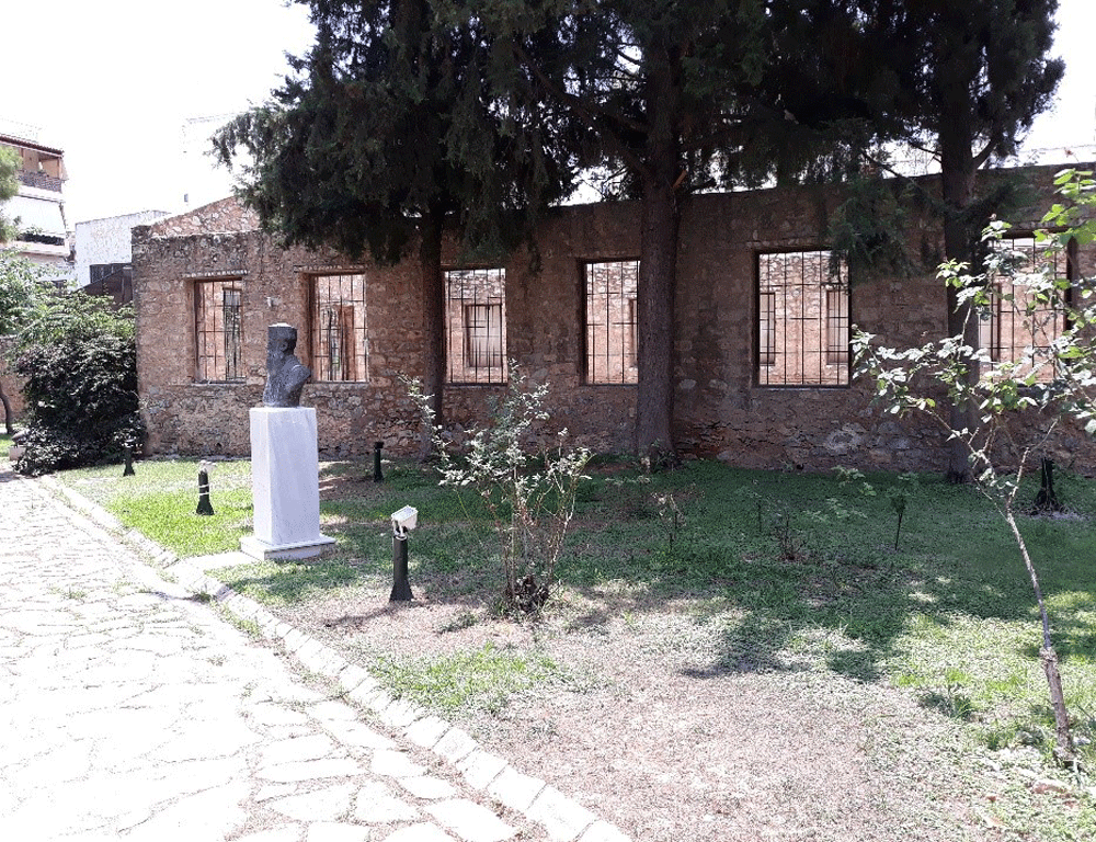
Memories of the original formation of the area are preserved through its name itself but also through the preservation of the original names of the streets. Undoubtedly, the existence of the refugee houses themselves – despite their significant deterioration – and the preservation of the original city plan are elements that connect past and present. In the original refugee core we find street names inspired by toponyms of Asia Minor (Menemeni, Bursa, Magnesia, Iconium, etc.) but also names of persons who played a decisive role in refugee rehabilitation such as Henry Morgenthau [4], president of the first board of directors of the Refugee Relief Committee (Γκιζελή, 1989: 162). In this analysis, we must also mention the monuments related to the participation of the inhabitants of Nikea in the Resistance. These are monuments, metal plaques and statues related to a military operation called Mploko Kokkinias, that took place on August 17, 1944, where almost 8000 people were arrested (Μπλόκο Κοκκινιάς 2004: 56) and around 200 executed (Βόγλης, 2010: 160). Several square names such as Diamantos Koumbakis and Athena Mavrou in Neapolis bear the names of Resistance heroes. The paddock of the old carpet factory where the dramatic events of August 17 took place is today a symbol of the Resistance, a place of memory in the area (Photo 3). A municipal Museum of National Resistance operates in the area with the support of the Society for the Rescue of Historical Archives (EDIA).
Photo 3: View from the site of Mploko Kokkinias
Source: Field work. Toussi, 2022.
Epilogue
Elements of intangible and tangible heritage adumbrate the socio-spatial physiognomy of Nikea. Parts of the urban fabric maintain the connection to their original design giving evidence of the city’s expansion and development. Critical is the issue of dereliction regarding the old refugee houses, and also the gradual reduction of the intermediate multi-functional spaces in the city blocks. The existence of these spaces, combined with the passageways may function as a starting point for creating a green network by joining the individual spaces with existing green spaces of a larger scale, significantly improving the quality of life in the area.
Acknowledgements
Special thanks to Ms. Giannakis and Mr. Thomaidis, from the Region of Attica – Department of Social Care, for their support in the study of archival material (cartography and concession documents). Warm thanks to Mrs. Lekka, whose contribution and support was important throughout the research. I would also like to thank Mr. Giorgos Veranis for the provision of archival cartographic material for specific city blocks (loc. 159, 174) as well as Ms. Despina Triga for her support, on behalf of the municipality of Nikaia-Ag.I. Renti, enabling me to visit and survey a residence in the Germanika district. I would also like to warmly thank the families who live in the refugee houses that participated in my research both in the analysis of the social physiognomy of the area and in the mapping of refugee homes. I would also like to thank Professor Mr. George Varelidis, supervisor of my post-doctoral research entitled “Urban Topography Transformations and Public Space. The case of the refugee core of Nikea in Attica” Department of Civil Engineering, University of West Attica and my colleague Ms. Athina Mela, PhD Candidate of the School of Civil Engineering of the University of West Attica for the excellent cooperation throughout my research.
[1] Study of the deeds of transfer of building block no. 159, under no. 1642 (concerns an elevated floor of a two-story complex), no. 12056 ground floor of building block no. 159, no. ° 14161 of the built block no. 79 properties under nos. 3 and 4, title deeds from the Agricultural Bank, built block 174 property no. 31, no. 6987, built block 174 property no. 30, no. 16933
[2] see also the documentary Smyrna: The Destruction of a Cosmopolitan City – 1900-1922, by Μαρία Ιλιού και Alexandros Kitroev
[3] For more on the refugee houses in Germanika Quarter see Tousi E., Karadoulama K., Papaioannou I., Patsea A., Skrepi A., Spentza E., Voskos T., Zafeiropoulos G. (2023) Issues of Urban Conservation and Collective Memory. The case of the Asia Minor post-refugee urban neighborhood Germanika at Nikea, Piraeus, Greece. Journal of Sustainable Architecture and Civil Engineering, Kaunas University of Technology
Entry citation
Toussi, E. (2024) Initial planning and current situation of refugee housing and outdoor public spaces in the post-refugee urban settlement of Nikea in Attica, in Maloutas T., Spyrellis S. (eds) Athens Social Atlas. Digital compendium of texts and visual material. URL: https://www.athenssocialatlas.gr/en/article/refugee-housing-and-outdoor-public-spaces-in-nikea/ , DOI: 10.17902/20971.118
Atlas citation
Maloutas T., Spyrellis S. (eds) (2015) Athens Social Atlas. Digital compendium of texts and visual material. URL: https://www.athenssocialatlas.gr/en/ , DOI: 10.17902/20971.9
References
- Βόγλης, Π. (2010). Η ελληνική κοινωνία στην κατοχή. Αθήνα: Αλεξάνδρεια. ISBN 978-960-221-496-1.
- Clark B. (2009) Twice a Stranger: The Mass Expulsions that Forged Modern Greece and Turkey, Harvard University Press
- Γκιζελή Β. (1984) Κοινωνικοί Μετασχηματισμοί και προέλευση της Κοινωνικής Κατοικίας στην Ελλάδα 1920-1930 [Social transformations and origins of social housing in Greece 1920-1930], Επικαιρότητα, Αθήνα
- Δήμος Νίκαιας (2004) Το Μπλόκο της Κοκκινιάς, Χρονικό Μνήμης, 1944-2004, 60 χρόνια από το Μπλόκο της Κοκκινιάς, Δήμος Νίκαιας
- Exertzoglou, H. (2016). Children of Memory: Narratives of the Asia Minor Catastrophe and the Making of Refugee Identity in Interwar Greece. Journal of Modern Greek Studies. 34. 343-366. 10.1353/mgs.2016.0030., available at https://www.researchgate.net/publication/309315536_Children_of_Memory_Narratives_of_the_Asia_Minor_Catastrophe_and_the_Making_of_Refugee_Identity_in_Interwar_Greece
- Κουτελάκης Χ., Φωσκόλου Α. (1991) Πειραιάς και Συνοικισμοί, Βιβλιοπωλείον της «Εστίας»
- Λεοντίδου, Λ. (1989) Πόλεις της σιωπής [Cities of silence], Πολιτιστικό Τεχνολογικό Ίδρυμα ΕΤΒΑ, Αθήνα
- Νικολαΐδου ,Σ. (1993) Η κοινωνική οργάνωση του αστικού χώρου [Social organization of urban space] Παπαζήσης, Αθήνα.
- Papadopoulos, Y. (2013). The uprootedness as an ethnic marker and the introduction of Asia Minor as an imaginary “topos” in Greek films, available at https://www.researchgate.net/publication/259398395_The_uprootedness_as_an_ethnic_marker_and_the_introduction_of_Asia_Minor_as_an_imaginary_topos_in_Greek_films
- Παπαδοπούλου Α. (2003) Η Αττική Νίκαια, Νίκαια, ISBN 960-92131-0-3
- Pentzopoulos D. (1962), The Balkan Exchange of Minorities and Its Impact upon Greece, Mouton and Co, Paris.
- Σαρηγιάννης Γ.Μ. (2000) Αθήνα:1832-2000 [Athens 1832-2000], Εκδόσεις, Συμμετρία, Αθήνα
- Τούση Ε. (2014) Ο αστικός χώρος ως πεδίο μετασχηματισμών υπό το πρίσμα του προσφυγικού ζητήματος. Η περίπτωση της ευρύτερη περιοχής Αθήνας Πειραιά. [Urban socio-spatial transformations in the light of the refugee issue. The case of the urban agglomeration of Athens-Piraeus.] Διδακτορική Διατριβή, Εθνικό Μετσόβειο Πολυτεχνείο, Σχολή Αρχιτεκτόνων Μηχανικών, Τομέας Πολεοδομίας και Χωροταξίας διαθέσιμο στο https://thesis.ekt.gr/thesisBookReader/id/42796#page/1/mode/2up
- Tούση Ε. (2019) Μελετώντας το αποτύπωμα της Κοινωνικής Κατοικίας στην Περιφερειακή Ενότητα Πειραιά. Μια συγκριτική διερεύνηση. Μεταδιδακτορική έρευνα, Σχολή Αρχιτεκτόνων Μηχανικών ΕΜΠ, Τομέας Πολεοδομίας – Χωροταξίας
- Χίρσον Ρ. (2004) Κληρονόμοι της Μικρασιατικής Καταστροφής. Η κοινωνική Ζωή των Μικρασιατών Προσφύγων στον Πειραιά, Μορφωτικό Ίδρυμα Εθνικής Τραπέζης

