Social and spatial atlas of Refugee Piraeus
Christoforaki Katerina|Kyramargiou Eleni|Prentou Polina
Built Environment, Housing, Social Structure
2019 | Oct
“Refugee neighborhoods of Piraeus and historical memory: From emergence to prominence” is an interdisciplinary research project by the National Hellenic Research Foundation and National Technical University of Athens, which aimed at studying the entirety of refugee settlements established in the wider area of Piraeus after 1922. The purpose of this report is to briefly present the findings both on the social and the urban planning level of the research, which was completed a few months ago.
The urban refugee settlement in the wider area of Piraeus was a gradual process that had not been thoroughly studied until now. The research project attempted to examine the settlement, utilizing historical evidence, unprocessed archives, contemporaneous newspapers, as well as oral testimonies. At the same time, a large number of topographical diagrams and map extracts was collected from various services and involved entities. After their digitization and homogenization, these resources were placed in a cohesive framework, thus providing the possibilty for a comprehensive overview and understanding of the urban geography of the settlement.
These resources provided the opportunity to formulate a new historical narrative of the urban refugee settlement in Piraeus, as well as to discover and highlight specific points of interest, both from a historical and an urban planning perspective. The collected materials will be further processed and, along with a deeper exploration of the process of residential development, will constitute the foundation for the creation of the refugee atlas of the wider area of Piraeus.
Research goals
The stone two-story houses in Agios Ioannis Rentis, the ‘Germanika’ settlement in Kokkinia, the Agios Georgios settlement in Keratsini, the workers’ projects in Drapetsona are all aspects of social housing and methods for refugee and worker rehabilitation, adopted in order to resolve the housing issue over a time period spanning from the Asia Minor catastrophe to the end of the military junta of 1967. These housing models represent the various forms of settlement implemented by various entities, as well as the various housing schemes which attempted to reconcile the needs of each time period with the capabilities of each area. Beyond the isolated stories of refugee and worker rehabilitation lie only fragmentary studies, limited research, and unexplored or unprocessed archives. The histories of the neighborhoods of Piraeus, along with the history of social housing and housing policy of modern Greece for more than 50 years, remain unexplored fields for historians, social scientists, and urban planners alike.
The research project “Refugee neighborhoods of Pireaus and historical memory: From emergence to prominence” [1] was conducted from January 2017 until April 2018 by the Institute of Historical Research of the National Hellenic Research Foundation and the School of Architecture of the National Technical University of Athens and was funded by the Region of Attica. The aim of the project was to establish a framework of co-ordinated acts and actions, within which specific schemes could promote the emergence of historical memory of the space and its residents. The mass arrival of new population at an area, the reception and housing conditions, the tangled web of relationships with the central government, the local authorities, and the already settled, “old” residents, brought about a series of consequences, some of which were resloved through a constant search for firstly ad hoc and then long-term solutions, while others persisted for years as open, unresolved issues.
The housing policies of the modern Greek state attempted to respond to the demands of an ever-expanding urban population in need of state intervention and support (Γκιζελή 1984: 135-137, League of Nations 1924-1930). The refugee populations of the Asia Minor catastrophe, internal migrants and the “bombing sufferers” of the Second World War comprised the “vulnerable” social groups which required the assistance of the state and the contribution of responsible ministries in order to secure housing. Gradually, a number of the Asia Minor refugees moved into the settlements established by the Refugee Welfare Fund, the Refugee Rehabilitation Committee and the Ministry of Welfare on the outskirts of Piraeus, in uninhabited and isolated areas far from the existing residential networks. At the same time, refugees resided in makeshift huts and self-made sheds on lands which were originally appropriated and later expropriated by the State to house refugees temporarily or permanently, depending on the residential program implemented in each area (Λεοντίδου 1989: 205-2013, Καραδήμου-Γερολύμπου 2002: 64).
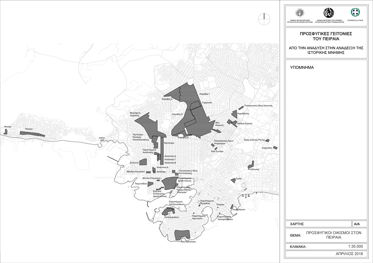
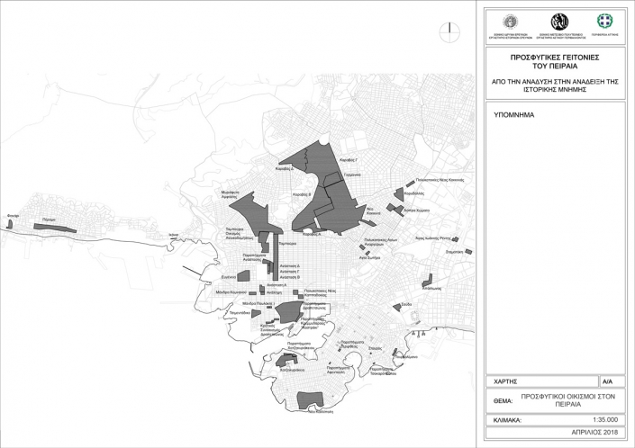
At the same time as the refugees, a large number of people from rural areas arrived at Piraeus looking for employment. Part of this population followed the same course of settlement as the refugees in the areas where they found work. In the industrial zone of Piraeus, workers-internal migrants added their own makeshift sheds right next to the ones of the refugees. Common paths and common problems united these people, regardless of their place of origin and the reasons for their settlement in the areas beside the factories of Piraeus. The bombardments of the Second World War, both by allies and enemies, razed their houses, leaving them homeless once again. The post-war urban reconstruction effort attempted to resolve the persistent problems of the urban rehabilitation of both refugee and non-refugee populations, as well as the new issues which arose during the war. An extensive program of urban reconstruction, introduced at the end of the 1940s and completed in the first years after the fall of the military junta, transformed the urban design map of Athens and Piraeus. This research focused on the urban development of Piraeus, starting from the first years after the refugee settlement. The objects of the research are the “type” and method of settlement, the provision or not of assistance and support by the responsible entities, while our interest centered on the urban evolution of the refugee settlements, from the first makeshift sheds to the implementation of the state program for urban rehabilitation at the end of the 1960s (Map 1). The research was conducted concurrently on three different levels of action.
Map 1: The total of refugee settlements in Piraeus (source: IHR/NTUA, 2018)
Locating and registering archival material
Research’s goal was to locate and register archival material related to refugee settlement from September 1922 until 1974. The search for such material was conducted in the Municipalities of: Nikaia – Agios Ioannis Rentis, Keratsini- Drapetsona, Piraeus, Koridallos, and Perama.
The complete resident registers for the original Towns and later the corresponding Municipalities survive fully processed and in very good condition in all aforementioned municipalities, from their year of establishment until today. At the Municipal Register Office survive also the books of the Towns and Municipalities from the year of their establishment until today, as well as the entirety of the Male Registry Records of each Municipality. All the data included in the records of the Citizens’ Register Office, the Municipal Register Office, and the Male Registry have been digitized and incorporated in a special computerized program for use by the municipal services.
In the Municipalities of Nikaia-Agios Ioannis Rentis and Keratsini-Drapetsona, we located fragmentary records of minutes and decisions of the Town Council of Nea Kokkinia, later renamed Municipality of Nikaia, of the Municipal Committee and the Governing Board from 1934 until 1974, and of the Municipality of Agios Georgios, later Municipality of Keratsini, from 1934 until 1974. They include information on the government structure of the Municipality, its economic functions and the everyday life of the people in the area, as well as the constant effort towards the housing and employment rehabilitation of the refugee residents. This archival material has not been comprehensively studied so far. In the Municipal Unit of Drapetsona, the entirety of the Municipal Records from 1951 to 1980 survives, both processed and accessible. In the Municipalities of Perama and Koridallos, no archival material related to the research project was located. In the Municipality of Piraeus, the archival material is kept in the Historical Archive, unprocessed and inaccessible.
Over the course of this research, there was a systematic effort to document archival collection catalogues and list availabilities referring to the formation of refugee neighborhoods and the organization of their daily life. Archival material was sought for and located at the Settlement Archive of the Centre for Asia Minor Studies, the Ministry of the Interior, the General State Archives of Greece, the Contemporary Social History Archives (ASKI) and the Hellenic Literary and Historical Archive (ELIA). Finally, we proceeded to catalogue the archive of the registry of residents eligible for housing rehabilitation, as well as the land registries for the Region of Attica. The aim was to categorize by municipality the totality of community registries, land registration and evaluation tables, land registries and indices available to the Department of Social Welfare of the Region of Attica. The material comprises approximately 150 book bound volumes of land registry catalogues and records, as well as tens of land registration and evaluation tables, where all lots and residences granted to refugee beneficiaries from 1923 until the end of the 1980s are recorded. Valuable both from a historical and an urban planning perspective, this material contains a multitude of data and evidence which had been heretofore unknown to scientific research.
Oral History and historical walks
The aim was to familiarize the participants with the local history of their area, as well as to set up Oral History groups by the interested citizens. The purpose of the introductory weekly seminars was to examine the historical backgrounds, the theory and the methodology of this particular field of the science of History, as well as to focus on the refugee history of each area and the evolution of the urban fabric. Upon the completion of the first cycle, groups were set up, their members chose specific thematic fields and they proceeded on making oral interviews and gathering relevant supporting material from their informants.
The goal was to create an audio-visual record of oral testimonies, which was given to the municipal libraries. The main objective was to involve the local population in this process: to create a live and open archive on the refugee history and an important research tool that can reveal aspects of refugees’ settlements and life.
Spatial documentation
The spatial change that has occurred with the refugees’ settlements is also documented by the mapping production of this period. In order to achieve this, a collection of cartographic material was carried out in a number of services, such as the Maps Department of the Ministry of Environmental and Climate Change, the collections of diagrams and maps of the Region of Attica and the technical and planning departments of the local municipalities of the Region of Piraeus.
For each refugee settlement, a separate settlement identity card was created. Its aim is to create a summary id that includes information on the construction and development of each settlement as well as its population and socio-economic data. The material consists of archive sources, secondary sources, census data, cartographic diagrams and maps, photographs, and testimonies of the inhabitants.
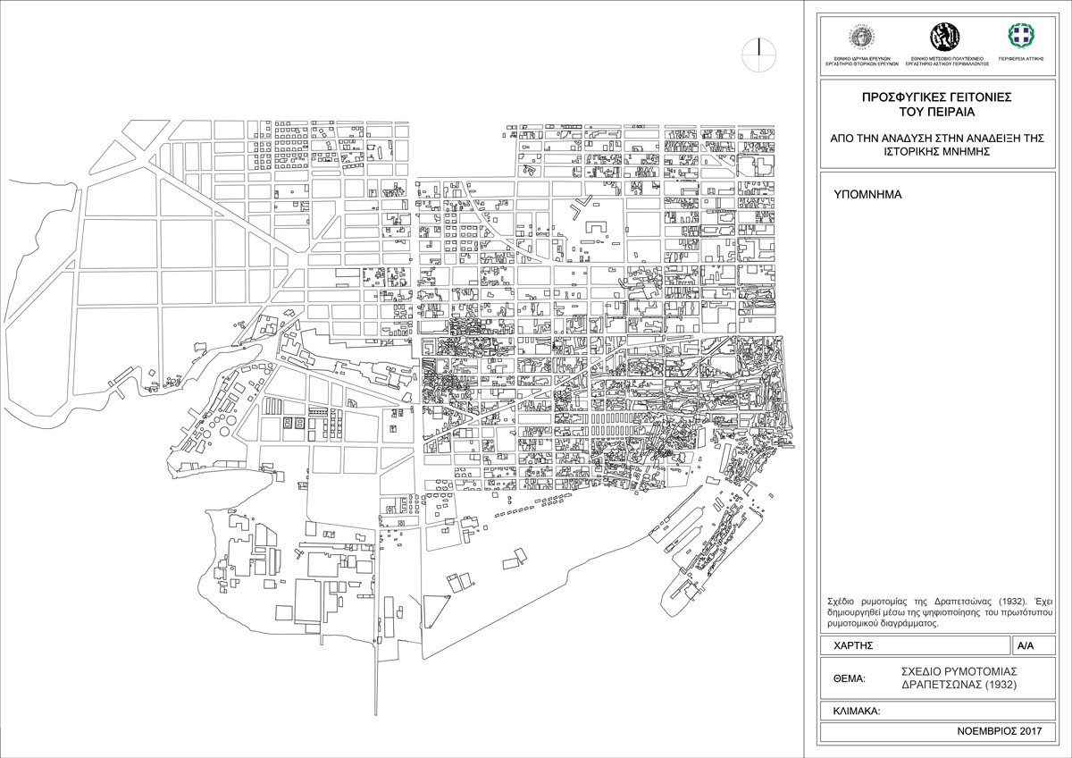
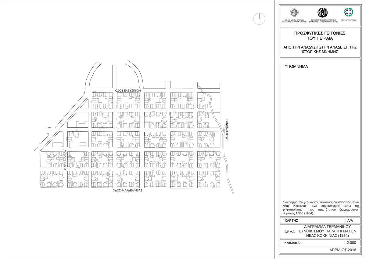
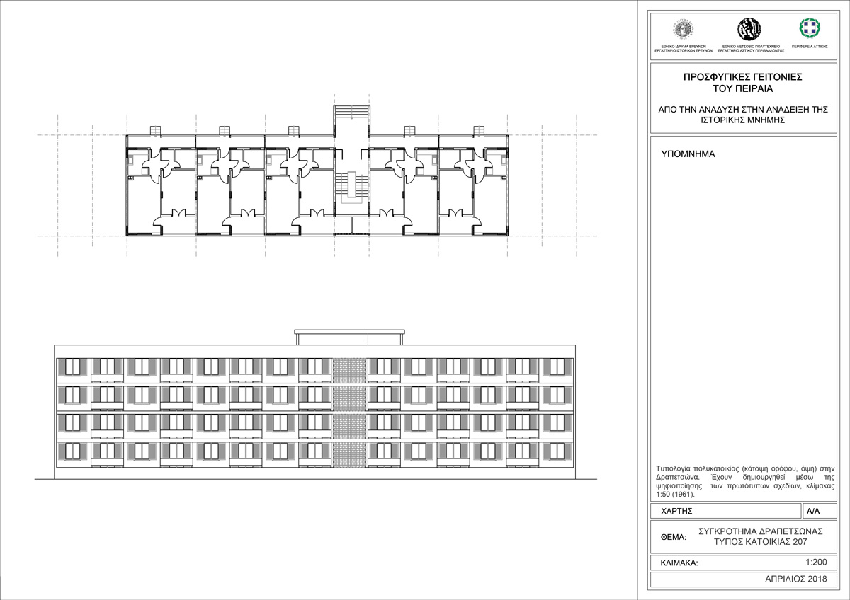
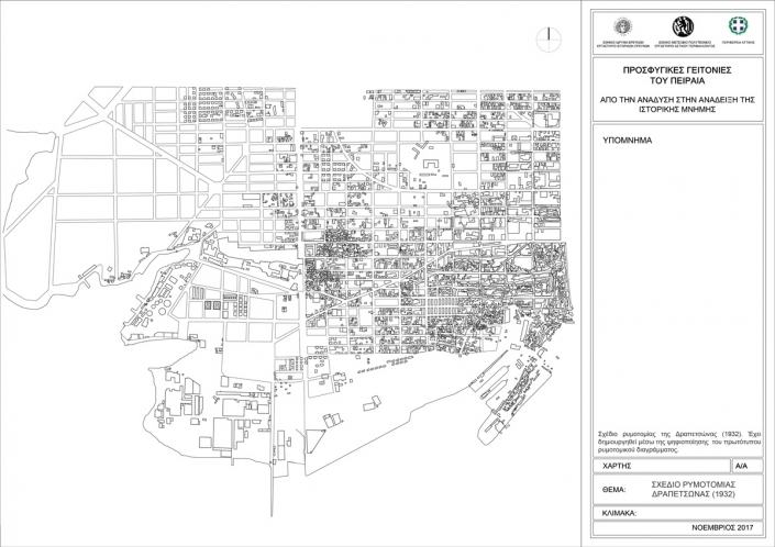
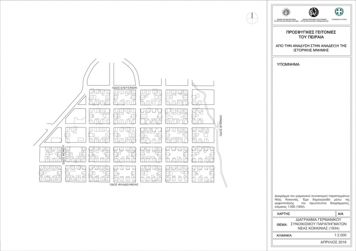
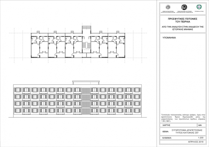
The material gathered comes from different sources and it is produced in different forms. Digitization aimed at transforming the various materials into a uniform and manageable form. The original maps and topographic diagrams were transferred to electronic files and redesigned from scratch piece-by-piece (Maps 2-4). This allowed the research team to interfere with their scale, the detail of the information they provide, to make comparisons among them and with the image of the city at a given moment. In this way, a coherent database with similar characteristics was created. It is comprised of the individual cartographic material, and it facilitates the complete representation and reading of the urban fabric.
Map 2: Plan of Drapetsona area (1932). It is created by digitization of the original mapping plan. (source: IHR/NTUA, 2018)
Map 3: Plan of «Germanika» settlement, Nea Kokkinia area (1934). It is created by digitization of the original plan. (source: IHR/NTUA, 2018)
Map 4: Building block typology, Drapetsona area (1961). It is created by digitization of the original mapping drawings. (source: IHR/NTUA, 2018)
The classification of the building facilities according to the policies followed in the housing issue can be divided in four categories (Γκιζελή 1984, 142-143):
1) Settlement in homes built by the Refugee Relief Fund, the Refugee Rehabilitation Committee and the Ministry of Welfare
2) Long-term hospitality in commandeered buildings
3) Self-housing without state intervention
4) Self-housing with state intervention/aid
The classification of the building facilities according to the type of buildings and the way in which they were implemented can be divided, in turn, in five categories of building typologies. The first is found in Drapetsona area where the informal self-made shelters dominate. The second is dominant in Kokkinia area, i.e. the wooden poor quality shelters provided by the state. The third case includes the building complexes built by the state. Complexes of this type are the ones in Agios Dionysios, Drapetsona area, and in Agioi Anargyroi, Palaia Kokkinia area, where the blocks form angular layouts that leave large central open spaces. The fourth one id the informal poor quality shelters built either inside the three-story building complexes, if space available, either at the city’s edges and outside the city master plan. The fifth one is the construction one or two-story buildings, single or double, by the Refugee Rehabilitation Committee and the state, like in Nea Kokkinia area. Lastly, there is also the case where the refugee’s built their homes themselves on given land. This is observed, indicatively, in Kokkinia and Keratsini areas.
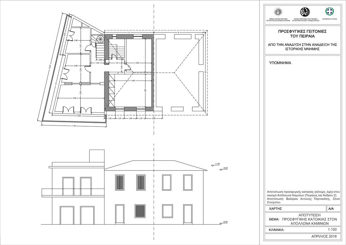
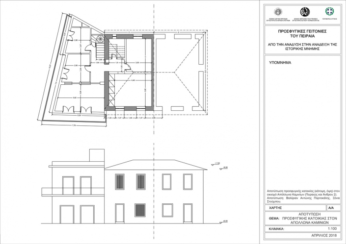
As part of the spatial documentation of the refugees’ settlements, the research group also measured indicative building typologies (Map 5).
Map 5: Measurement of a refugee house in Apollonas settlement, Kaminia area (source: IHR/NTUA, 2018)
The final product of the spatial and mapping documentation of the historical evolution of the refugees’ settlements formed a digital interactive atlas. The separate parts of the maps are collected and grouped together by time period. Then, they are placed and mapped to the digital background of the wider Piraeus area. The atlas documents the creation of the smaller settlements’ cells and the overall galaxy of refugees’ settlements or infrastructure that were found in the Piraeus area. Navigating through the different time periods, it is feasible to represent and understand the evolution of the urban fabric, the sprawl of the refugees’ settlements, as well as their integration in the city area.
The assignment of the individual mapping material to an overall and larger digital background is a time-consuming procedure, as the information is on a case-to-case base, and can rarely find a direct correlation to current advanced cartographic backgrounds. This digital tool of the representation of the creation of the settlements in time periods hopes to provide means for a profound understanding of the mechanisms of the city that lead to its expansion and the integration of those newly created areas.
The total amount of the data collected and documented during the research program is planned to be mapped and included in the digital interactive atlas, open and accessible to the public and the research community. It is worth to be mentioned that the creation of the digital atlas is dynamic and the time-lapse could be expanded to cover the whole evolution of the city, from its creation until today.
First conclusions – Results of the research program
The research program “ “Refugee neighborhoods of Piraeus and historical memory: From emergence to prominence” has attempted for the first time to approach the issue of the creation of refugees’ settlements in the broader Piraeus area both historically and spatially, combining methodological tools and research approaches of the two different disciplines. Historians and architects-urban planners have worked systematically together in order to jointly record and document the evolution of the refugees’ settlements. During the research program, various archival resources were found and combined together to set up the atlas. Urban planning maps were combined with municipal decisions and oral testimonies as to be able to clearly define the boundaries of the refugees’ neightbourhoods and the stories of the people who lived there. Archival press material and other sources were also used as complementary to the research.
For the first time, the research covered the archival and cartographic material from the archive of the registers of beneficiaries of housing rehabilitation and of the cadastral plans of the Region of Attica. Apart from the mapping of the rehabilitation process -that is, the property itself, its cost and other such data- the archive also includes the individual profile of each beneficiary. So, it is given the opportunity to monitor the bureaucracy mechanism since the application for housing rehabilitation up to the moment of the issuance of the definitive concession.
Both the profile of the refugee family and the bureaucratic mechanism are two fields that historically have not been studied so far. The research until now has highlighted the complexity of refugee rehabilitation, the different types of settlements, but also the different progress of the programs per area, and the constant movement of the refugees’ population in order to obtain a house. The complexity of the bureaucratic mechanism and the time needed for the competition of the housing rehabilitation process are the two main fields that the research attempts to focus on. Also, the oral history groups attempt to give voice to the refugee people and struggled to regain their lives and homelands. It has to be mentioned that the refugee history of Piraeus area is not a uniform story. It has many variations reflected both in the type or the time of the settlements, and they are directly related to the social and economic characteristics of the refugees themselves.
[1] Research project IHR-NTUA “Refugee neighborhoods of Piraeus and historical memory: From emergence to prominence” (2018). Scientists responsible: Dimitris Dimitropoulos (Research Director IHR/NHRF), Nikos Belavilas (Associate Professor NTUA). Co-ordinator: Eleni Kiramargiou (PhD in History, IHR/NHRF associate). Researchers: Manos Avgeridis (Historian, PhD candidate at NKUA), Anna Lamprou (MSc in Architecture and Urban Planning, PhD candidate NTUA), Aleksandra Mourgou (MSc in Architecture and Urban Planning, PhD candidate NTUA), Polina Prentou (MSc in Architecture and Urban Planning, PhD candidate NTUA), Leonardos Strifounias-Polemis (Geographer), Katerina Christoforaki (MSc in Architecture and Urban Planning, PhD candidate NTUA), Christos Chrisanthakopoulos (Historian, IHR/NHRF associate). Detailed information on the actions of the research project can be found on the website of the project: http://prosfigikospireas.blogspot.com/p/blog-page.html (last update: 7.6.2019)
Entry citation
Christoforaki, K., Kyramargiou, E., Prentou, P. (2019) Social and spatial atlas of Refugee Piraeus, in Maloutas T., Spyrellis S. (eds) Athens Social Atlas. Digital compendium of texts and visual material. URL: https://www.athenssocialatlas.gr/en/article/social-and-spatial-atlas-of-refugee-pireaus/ , DOI: 10.17902/20971.91
Atlas citation
Maloutas T., Spyrellis S. (eds) (2015) Athens Social Atlas. Digital compendium of texts and visual material. URL: https://www.athenssocialatlas.gr/en/ , DOI: 10.17902/20971.9
Bibliography
- Βασιλείου Ιωάννης (1944) Η λαϊκή κατοικία. Αθήνα: Π.Α. Διαλησμά.
- Καραδήμου-Γερόλυμπου Αλέκα (2002) Πόλεις και ύπαιθρος. Στο Χατζηιωσήφ Χρήστος (επιμ.), Ιστορία της Ελλάδας του 20ού αιώνα, Ο Μεσοπόλεμος 1922-1940, τ. Β1. Αθήνα: Βιβλιόραμα, σ. 59-105.
- Γκιζελή Βίκα (1984) Κοινωνικοί Μετασχηματισμοί και προέλευση της κοινωνικής κατοικίας στην Ελλάδα, 1920-1930. Αθήνα: Επικαιρότητα.
- Hirschon Renée (2004) Κληρονόμοι της Μικρασιατικής Καταστροφής. Η κοινωνική ζωή των μικρασιατών προσφύγων στον Πειραιά. Αθήνα: ΜΙΕΤ.
- Κυραμαργιού Ελένη (2019) Δραπετσώνα 1922-1967. Ένας κόσμος στην άκρη του κόσμου. Αθήνα: ΕΙΕ.
- Λεοντίδου Λίλα (1989) Πόλεις της Σιωπής. Εργατικός εποικισμός της Αθήνας και του Πειραιά, 1909-1940. Αθήνα: ΕΤΒΑ ΠΤΙ.
- Μιτζάλης Νικόλας (2008) Παραγωγή Κατοικίας και αστικός χώρος τον Μεσοπόλεμο. Αθήνα: Futura.
- Πολύζος Γιάννης (1984) Η εγκατάσταση των προσφύγων του 1922: Μια οριακή περίπτωση αστικοποίησης. Αθήνα: ΕΜΠ.
- League of Nations, Greece: Quarterly Report of the Refugee Settlement Commission, Γενεύη 1924–1930, τχ. 1 (1924)–τχ. 20 (1928).
